You are here: Home > Network List > CC - Cascade Chain Volcano Monitoring Stations List
> Station TIMB Timberline, OR > Earthquake Result Viewer
TIMB Timberline, OR - Earthquake Result Viewer
| Earthquake location: |
Central Mid-Atlantic Ridge |
| Earthquake latitude/longitude: |
7.7/-37.2 |
| Earthquake time(UTC): |
2020/09/06 (250) 06:51:19 GMT |
| Earthquake Depth: |
10 km |
| Earthquake Magnitude: |
6.7 Mww |
| Earthquake Catalog/Contributor: |
NEIC PDE/us |
|
| Network: |
CC Cascade Chain Volcano Monitoring |
| Station: |
TIMB Timberline, OR |
| Lat/Lon: |
45.34 N/121.71 W |
| Elevation: |
1869 m |
|
| Distance: |
80.7 deg |
| Az: |
314.651 deg |
| Baz: |
88.469 deg |
| Ray Param: |
0.048090726 |
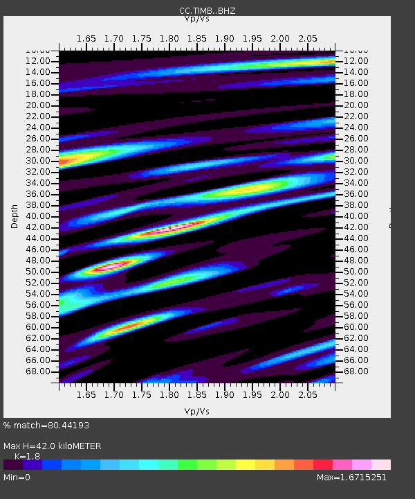
| Estimated Moho Depth: |
42.0 km |
| Estimated Crust Vp/Vs: |
1.80 |
| Assumed Crust Vp: |
6.597 km/s |
| Estimated Crust Vs: |
3.665 km/s |
| Estimated Crust Poisson's Ratio: |
0.28 |
|
| Radial Match: |
80.44193 % |
| Radial Bump: |
400 |
| Transverse Match: |
86.81149 % |
| Transverse Bump: |
400 |
| SOD ConfigId: |
22732711 |
| Insert Time: |
2020-09-20 07:00:42.333 +0000 |
| GWidth: |
2.5 |
| Max Bumps: |
400 |
| Tol: |
0.001 |
|

Signal To Noise
| Channel | StoN | STA | LTA |
| CC:TIMB: :BHZ:20200906T07:03:00.860018Z | 4.697225 | 4.407165E-7 | 9.3824866E-8 |
| CC:TIMB: :BHN:20200906T07:03:00.860018Z | 0.96003735 | 1.4712576E-7 | 1.5325004E-7 |
| CC:TIMB: :BHE:20200906T07:03:00.860018Z | 1.0926801 | 2.7309295E-7 | 2.4992946E-7 |
| Arrivals |
| Ps | 5.2 SECOND |
| PpPs | 17 SECOND |
| PsPs/PpSs | 23 SECOND |


