You are here: Home > Network List > CN - Canadian National Seismograph Network Stations List
> Station TBO Thunder Bay, ON, CA > Earthquake Result Viewer
TBO Thunder Bay, ON, CA - Earthquake Result Viewer
| Earthquake location: |
Central Mid-Atlantic Ridge |
| Earthquake latitude/longitude: |
7.7/-37.2 |
| Earthquake time(UTC): |
2020/09/06 (250) 06:51:19 GMT |
| Earthquake Depth: |
10 km |
| Earthquake Magnitude: |
6.7 Mww |
| Earthquake Catalog/Contributor: |
NEIC PDE/us |
|
| Network: |
CN Canadian National Seismograph Network |
| Station: |
TBO Thunder Bay, ON, CA |
| Lat/Lon: |
48.65 N/89.41 W |
| Elevation: |
475 m |
|
| Distance: |
59.8 deg |
| Az: |
322.698 deg |
| Baz: |
115.085 deg |
| Ray Param: |
0.06192617 |
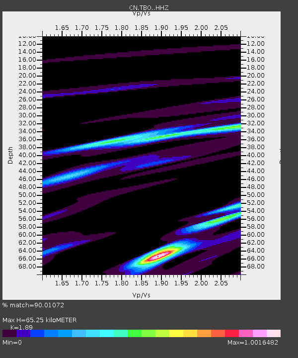
| Estimated Moho Depth: |
65.25 km |
| Estimated Crust Vp/Vs: |
1.89 |
| Assumed Crust Vp: |
6.467 km/s |
| Estimated Crust Vs: |
3.422 km/s |
| Estimated Crust Poisson's Ratio: |
0.31 |
|
| Radial Match: |
90.01072 % |
| Radial Bump: |
269 |
| Transverse Match: |
71.893936 % |
| Transverse Bump: |
400 |
| SOD ConfigId: |
22732711 |
| Insert Time: |
2020-09-20 07:04:50.428 +0000 |
| GWidth: |
2.5 |
| Max Bumps: |
400 |
| Tol: |
0.001 |
|

Signal To Noise
| Channel | StoN | STA | LTA |
| CN:TBO: :HHZ:20200906T07:00:53.430025Z | 2.9686067 | 1.268014E-6 | 4.2714112E-7 |
| CN:TBO: :HHN:20200906T07:00:53.430025Z | 0.7831952 | 1.8999056E-7 | 2.425839E-7 |
| CN:TBO: :HHE:20200906T07:00:53.430025Z | 2.3525167 | 6.836185E-7 | 2.905903E-7 |
| Arrivals |
| Ps | 9.4 SECOND |
| PpPs | 28 SECOND |
| PsPs/PpSs | 37 SECOND |


