You are here: Home > Network List > GB - Great Britain Seismograph Network Stations List
> Station MCH1 MICHAELCHURCH, WALES > Earthquake Result Viewer
MCH1 MICHAELCHURCH, WALES - Earthquake Result Viewer
| Earthquake location: |
Central Mid-Atlantic Ridge |
| Earthquake latitude/longitude: |
7.7/-37.2 |
| Earthquake time(UTC): |
2020/09/06 (250) 06:51:19 GMT |
| Earthquake Depth: |
10 km |
| Earthquake Magnitude: |
6.7 Mww |
| Earthquake Catalog/Contributor: |
NEIC PDE/us |
|
| Network: |
GB Great Britain Seismograph Network |
| Station: |
MCH1 MICHAELCHURCH, WALES |
| Lat/Lon: |
52.00 N/3.00 W |
| Elevation: |
219 m |
|
| Distance: |
52.3 deg |
| Az: |
26.059 deg |
| Baz: |
224.767 deg |
| Ray Param: |
0.066829026 |
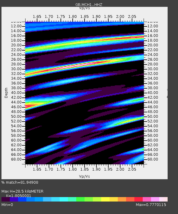
| Estimated Moho Depth: |
28.5 km |
| Estimated Crust Vp/Vs: |
1.81 |
| Assumed Crust Vp: |
6.182 km/s |
| Estimated Crust Vs: |
3.425 km/s |
| Estimated Crust Poisson's Ratio: |
0.28 |
|
| Radial Match: |
81.94908 % |
| Radial Bump: |
294 |
| Transverse Match: |
68.36284 % |
| Transverse Bump: |
333 |
| SOD ConfigId: |
22732711 |
| Insert Time: |
2020-09-20 07:07:40.539 +0000 |
| GWidth: |
2.5 |
| Max Bumps: |
400 |
| Tol: |
0.001 |
|

Signal To Noise
| Channel | StoN | STA | LTA |
| GB:MCH1: :HHZ:20200906T06:59:59.790011Z | 5.9841685 | 4.1242683E-7 | 6.8919654E-8 |
| GB:MCH1: :HHN:20200906T06:59:59.790011Z | 1.87643 | 1.8020205E-7 | 9.603452E-8 |
| GB:MCH1: :HHE:20200906T06:59:59.790011Z | 2.1137135 | 1.1807413E-7 | 5.5860983E-8 |
| Arrivals |
| Ps | 3.9 SECOND |
| PpPs | 12 SECOND |
| PsPs/PpSs | 16 SECOND |


