You are here: Home > Network List > GM - US Geological Survey Networks Stations List
> Station NMP01 New Mexico Permian - Site# 01 > Earthquake Result Viewer
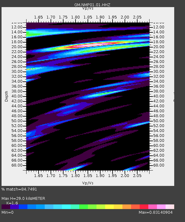
NMP01 New Mexico Permian - Site# 01 - Earthquake Result Viewer
| Earthquake location: |
Central Mid-Atlantic Ridge |
| Earthquake latitude/longitude: |
7.7/-37.2 |
| Earthquake time(UTC): |
2020/09/06 (250) 06:51:19 GMT |
| Earthquake Depth: |
10 km |
| Earthquake Magnitude: |
6.7 Mww |
| Earthquake Catalog/Contributor: |
NEIC PDE/us |
|
| Network: |
GM US Geological Survey Networks |
| Station: |
NMP01 New Mexico Permian - Site# 01 |
| Lat/Lon: |
32.20 N/103.86 W |
| Elevation: |
1048 m |
|
| Distance: |
66.2 deg |
| Az: |
301.716 deg |
| Baz: |
96.002 deg |
| Ray Param: |
0.057780553 |
| Estimated Moho Depth: |
29.0 km |
| Estimated Crust Vp/Vs: |
1.60 |
| Assumed Crust Vp: |
6.129 km/s |
| Estimated Crust Vs: |
3.831 km/s |
| Estimated Crust Poisson's Ratio: |
0.18 |
|
| Radial Match: |
84.7491 % |
| Radial Bump: |
400 |
| Transverse Match: |
66.40752 % |
| Transverse Bump: |
400 |
| SOD ConfigId: |
22732711 |
| Insert Time: |
2020-09-20 07:08:09.123 +0000 |
| GWidth: |
2.5 |
| Max Bumps: |
400 |
| Tol: |
0.001 |
|

Signal To Noise
| Channel | StoN | STA | LTA |
| GM:NMP01:01:HHZ:20200906T07:01:35.594027Z | 6.693612 | 9.1667016E-7 | 1.3694701E-7 |
| GM:NMP01:01:HHN:20200906T07:01:35.594027Z | 1.0634973 | 1.9782229E-7 | 1.8601108E-7 |
| GM:NMP01:01:HHE:20200906T07:01:35.594027Z | 2.2770193 | 4.7458565E-7 | 2.0842408E-7 |
| Arrivals |
| Ps | 3.0 SECOND |
| PpPs | 12 SECOND |
| PsPs/PpSs | 15 SECOND |


