You are here: Home > Network List > GS - US Geological Survey Networks Stations List
> Station VEA2 VEA1 > Earthquake Result Viewer
VEA2 VEA1 - Earthquake Result Viewer
| Earthquake location: |
Central Mid-Atlantic Ridge |
| Earthquake latitude/longitude: |
7.7/-37.2 |
| Earthquake time(UTC): |
2020/09/06 (250) 06:51:19 GMT |
| Earthquake Depth: |
10 km |
| Earthquake Magnitude: |
6.7 Mww |
| Earthquake Catalog/Contributor: |
NEIC PDE/us |
|
| Network: |
GS US Geological Survey Networks |
| Station: |
VEA2 VEA1 |
| Lat/Lon: |
34.94 N/106.46 W |
| Elevation: |
1844 m |
|
| Distance: |
68.6 deg |
| Az: |
304.421 deg |
| Baz: |
95.611 deg |
| Ray Param: |
0.05618417 |
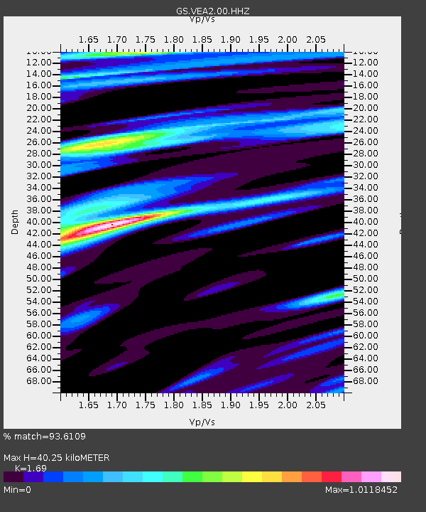
| Estimated Moho Depth: |
40.25 km |
| Estimated Crust Vp/Vs: |
1.69 |
| Assumed Crust Vp: |
6.502 km/s |
| Estimated Crust Vs: |
3.847 km/s |
| Estimated Crust Poisson's Ratio: |
0.23 |
|
| Radial Match: |
93.6109 % |
| Radial Bump: |
400 |
| Transverse Match: |
81.21425 % |
| Transverse Bump: |
400 |
| SOD ConfigId: |
22732711 |
| Insert Time: |
2020-09-20 07:09:03.578 +0000 |
| GWidth: |
2.5 |
| Max Bumps: |
400 |
| Tol: |
0.001 |
|

Signal To Noise
| Channel | StoN | STA | LTA |
| GS:VEA2:00:HHZ:20200906T07:01:50.970003Z | 7.0219936 | 4.926018E-7 | 7.015127E-8 |
| GS:VEA2:00:HH1:20200906T07:01:50.970003Z | 1.2983904 | 8.0834866E-8 | 6.2257755E-8 |
| GS:VEA2:00:HH2:20200906T07:01:50.970003Z | 1.9172089 | 1.7309105E-7 | 9.028283E-8 |
| Arrivals |
| Ps | 4.5 SECOND |
| PpPs | 16 SECOND |
| PsPs/PpSs | 20 SECOND |


