You are here: Home > Network List > LD - Lamont-Doherty Cooperative Seismographic Network Stations List
> Station MVL Millersville University, PA > Earthquake Result Viewer
MVL Millersville University, PA - Earthquake Result Viewer
| Earthquake location: |
Central Mid-Atlantic Ridge |
| Earthquake latitude/longitude: |
7.7/-37.2 |
| Earthquake time(UTC): |
2020/09/06 (250) 06:51:19 GMT |
| Earthquake Depth: |
10 km |
| Earthquake Magnitude: |
6.7 Mww |
| Earthquake Catalog/Contributor: |
NEIC PDE/us |
|
| Network: |
LD Lamont-Doherty Cooperative Seismographic Network |
| Station: |
MVL Millersville University, PA |
| Lat/Lon: |
40.00 N/76.35 W |
| Elevation: |
91 m |
|
| Distance: |
47.5 deg |
| Az: |
318.878 deg |
| Baz: |
121.947 deg |
| Ray Param: |
0.069955505 |
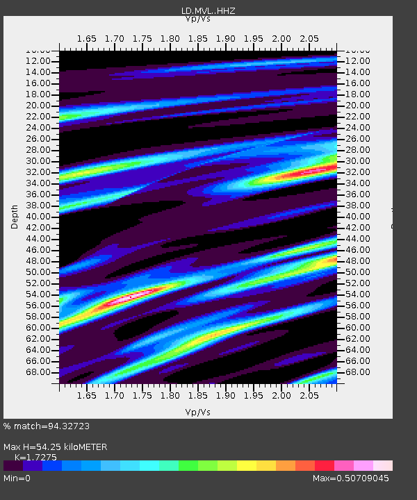
| Estimated Moho Depth: |
54.25 km |
| Estimated Crust Vp/Vs: |
1.73 |
| Assumed Crust Vp: |
6.419 km/s |
| Estimated Crust Vs: |
3.716 km/s |
| Estimated Crust Poisson's Ratio: |
0.25 |
|
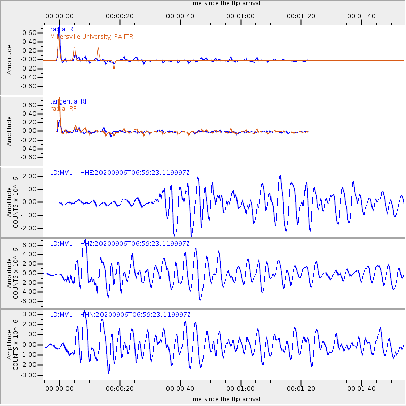
| Radial Match: |
94.32723 % |
| Radial Bump: |
225 |
| Transverse Match: |
90.39729 % |
| Transverse Bump: |
372 |
| SOD ConfigId: |
22732711 |
| Insert Time: |
2020-09-20 07:11:12.037 +0000 |
| GWidth: |
2.5 |
| Max Bumps: |
400 |
| Tol: |
0.001 |
|
Signal To Noise
| Channel | StoN | STA | LTA |
| LD:MVL: :HHZ:20200906T06:59:23.119997Z | 6.6784725 | 1.0445045E-6 | 1.5639871E-7 |
| LD:MVL: :HHN:20200906T06:59:23.119997Z | 3.280223 | 5.4325636E-7 | 1.6561569E-7 |
| LD:MVL: :HHE:20200906T06:59:23.119997Z | 3.3625634 | 4.288912E-7 | 1.2754889E-7 |
| Arrivals |
| Ps | 6.5 SECOND |
| PpPs | 22 SECOND |
| PsPs/PpSs | 28 SECOND |


