You are here: Home > Network List > N4 - Central and EAstern US Network Stations List
> Station D62A Allapoint, Allagash, ME, USA > Earthquake Result Viewer
D62A Allapoint, Allagash, ME, USA - Earthquake Result Viewer
| Earthquake location: |
Central Mid-Atlantic Ridge |
| Earthquake latitude/longitude: |
7.7/-37.2 |
| Earthquake time(UTC): |
2020/09/06 (250) 06:51:19 GMT |
| Earthquake Depth: |
10 km |
| Earthquake Magnitude: |
6.7 Mww |
| Earthquake Catalog/Contributor: |
NEIC PDE/us |
|
| Network: |
N4 Central and EAstern US Network |
| Station: |
D62A Allapoint, Allagash, ME, USA |
| Lat/Lon: |
47.08 N/69.05 W |
| Elevation: |
189 m |
|
| Distance: |
47.7 deg |
| Az: |
330.852 deg |
| Baz: |
135.06 deg |
| Ray Param: |
0.06981764 |
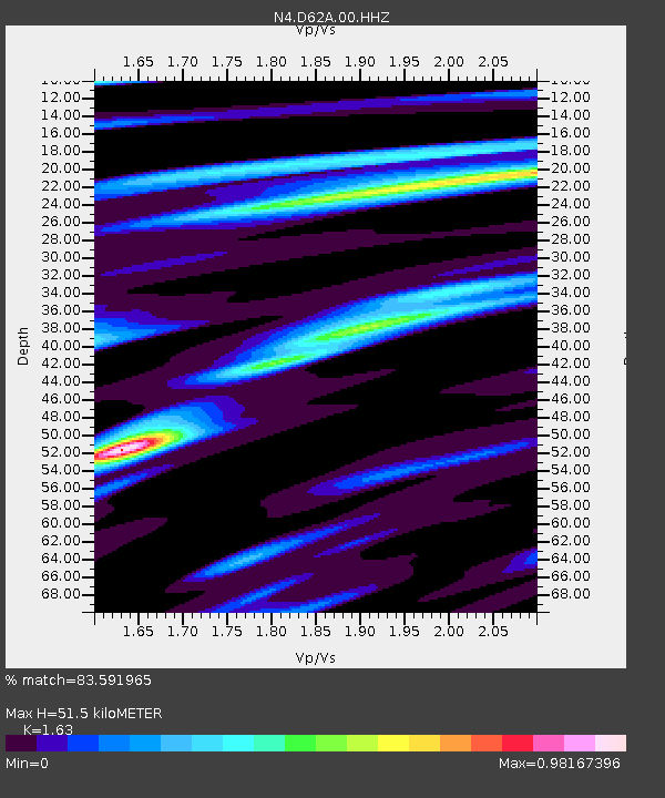
| Estimated Moho Depth: |
51.5 km |
| Estimated Crust Vp/Vs: |
1.63 |
| Assumed Crust Vp: |
6.419 km/s |
| Estimated Crust Vs: |
3.938 km/s |
| Estimated Crust Poisson's Ratio: |
0.20 |
|
| Radial Match: |
83.591965 % |
| Radial Bump: |
251 |
| Transverse Match: |
76.344536 % |
| Transverse Bump: |
400 |
| SOD ConfigId: |
22732711 |
| Insert Time: |
2020-09-20 07:12:14.811 +0000 |
| GWidth: |
2.5 |
| Max Bumps: |
400 |
| Tol: |
0.001 |
|

Signal To Noise
| Channel | StoN | STA | LTA |
| N4:D62A:00:HHZ:20200906T06:59:25.039004Z | 3.4929647 | 1.0964468E-6 | 3.1390147E-7 |
| N4:D62A:00:HH1:20200906T06:59:25.039004Z | 4.2289863 | 4.818715E-7 | 1.1394492E-7 |
| N4:D62A:00:HH2:20200906T06:59:25.039004Z | 1.4477538 | 4.7733226E-7 | 3.2970541E-7 |
| Arrivals |
| Ps | 5.4 SECOND |
| PpPs | 20 SECOND |
| PsPs/PpSs | 25 SECOND |


