You are here: Home > Network List > N4 - Central and EAstern US Network Stations List
> Station I45A Fountain, MI, USA > Earthquake Result Viewer
I45A Fountain, MI, USA - Earthquake Result Viewer
| Earthquake location: |
Central Mid-Atlantic Ridge |
| Earthquake latitude/longitude: |
7.7/-37.2 |
| Earthquake time(UTC): |
2020/09/06 (250) 06:51:19 GMT |
| Earthquake Depth: |
10 km |
| Earthquake Magnitude: |
6.7 Mww |
| Earthquake Catalog/Contributor: |
NEIC PDE/us |
|
| Network: |
N4 Central and EAstern US Network |
| Station: |
I45A Fountain, MI, USA |
| Lat/Lon: |
44.04 N/86.23 W |
| Elevation: |
215 m |
|
| Distance: |
55.9 deg |
| Az: |
318.878 deg |
| Baz: |
115.342 deg |
| Ray Param: |
0.06451674 |
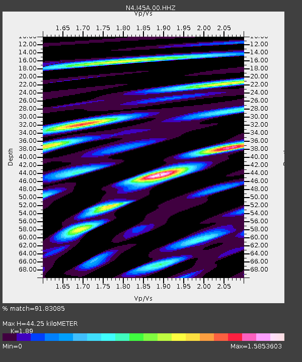
| Estimated Moho Depth: |
44.25 km |
| Estimated Crust Vp/Vs: |
1.89 |
| Assumed Crust Vp: |
6.53 km/s |
| Estimated Crust Vs: |
3.455 km/s |
| Estimated Crust Poisson's Ratio: |
0.31 |
|
| Radial Match: |
91.83085 % |
| Radial Bump: |
400 |
| Transverse Match: |
77.57414 % |
| Transverse Bump: |
400 |
| SOD ConfigId: |
22732711 |
| Insert Time: |
2020-09-20 07:12:35.439 +0000 |
| GWidth: |
2.5 |
| Max Bumps: |
400 |
| Tol: |
0.001 |
|

Signal To Noise
| Channel | StoN | STA | LTA |
| N4:I45A:00:HHZ:20200906T07:00:25.709017Z | 5.128505 | 1.4597421E-6 | 2.8463307E-7 |
| N4:I45A:00:HH1:20200906T07:00:25.709017Z | 1.9491241 | 4.5817407E-7 | 2.3506666E-7 |
| N4:I45A:00:HH2:20200906T07:00:25.709017Z | 3.7673323 | 8.464382E-7 | 2.246784E-7 |
| Arrivals |
| Ps | 6.3 SECOND |
| PpPs | 19 SECOND |
| PsPs/PpSs | 25 SECOND |


