You are here: Home > Network List > N4 - Central and EAstern US Network Stations List
> Station L59A Walton, NY, USA > Earthquake Result Viewer
L59A Walton, NY, USA - Earthquake Result Viewer
| Earthquake location: |
Central Mid-Atlantic Ridge |
| Earthquake latitude/longitude: |
7.7/-37.2 |
| Earthquake time(UTC): |
2020/09/06 (250) 06:51:19 GMT |
| Earthquake Depth: |
10 km |
| Earthquake Magnitude: |
6.7 Mww |
| Earthquake Catalog/Contributor: |
NEIC PDE/us |
|
| Network: |
N4 Central and EAstern US Network |
| Station: |
L59A Walton, NY, USA |
| Lat/Lon: |
42.19 N/75.04 W |
| Elevation: |
677 m |
|
| Distance: |
47.9 deg |
| Az: |
322.085 deg |
| Baz: |
124.963 deg |
| Ray Param: |
0.06973314 |
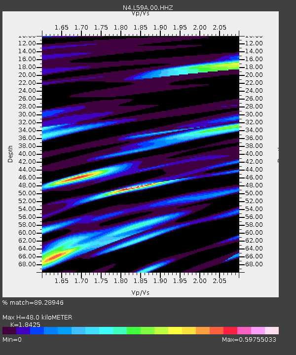
| Estimated Moho Depth: |
48.0 km |
| Estimated Crust Vp/Vs: |
1.84 |
| Assumed Crust Vp: |
6.419 km/s |
| Estimated Crust Vs: |
3.484 km/s |
| Estimated Crust Poisson's Ratio: |
0.29 |
|
| Radial Match: |
89.28946 % |
| Radial Bump: |
335 |
| Transverse Match: |
80.953186 % |
| Transverse Bump: |
383 |
| SOD ConfigId: |
22732711 |
| Insert Time: |
2020-09-20 07:13:01.459 +0000 |
| GWidth: |
2.5 |
| Max Bumps: |
400 |
| Tol: |
0.001 |
|

Signal To Noise
| Channel | StoN | STA | LTA |
| N4:L59A:00:HHZ:20200906T06:59:26.089999Z | 6.25085 | 1.5297194E-6 | 2.447218E-7 |
| N4:L59A:00:HH1:20200906T06:59:26.089999Z | 3.2685452 | 5.483468E-7 | 1.677648E-7 |
| N4:L59A:00:HH2:20200906T06:59:26.089999Z | 2.7970266 | 7.743219E-7 | 2.768375E-7 |
| Arrivals |
| Ps | 6.7 SECOND |
| PpPs | 20 SECOND |
| PsPs/PpSs | 27 SECOND |


