You are here: Home > Network List > N4 - Central and EAstern US Network Stations List
> Station P61A Hammonton, NJ, USA > Earthquake Result Viewer
P61A Hammonton, NJ, USA - Earthquake Result Viewer

| Earthquake location: |
Central Mid-Atlantic Ridge |
| Earthquake latitude/longitude: |
7.7/-37.2 |
| Earthquake time(UTC): |
2020/09/06 (250) 06:51:19 GMT |
| Earthquake Depth: |
10 km |
| Earthquake Magnitude: |
6.7 Mww |
| Earthquake Catalog/Contributor: |
NEIC PDE/us |
|
| Network: |
N4 Central and EAstern US Network |
| Station: |
P61A Hammonton, NJ, USA |
| Lat/Lon: |
39.67 N/74.79 W |
| Elevation: |
22 m |
|
| Distance: |
46.3 deg |
| Az: |
319.388 deg |
| Baz: |
123.29 deg |
| Ray Param: |
0.07074194 |
| Estimated Moho Depth: |
36.5 km |
| Estimated Crust Vp/Vs: |
1.71 |
| Assumed Crust Vp: |
6.287 km/s |
| Estimated Crust Vs: |
3.672 km/s |
| Estimated Crust Poisson's Ratio: |
0.24 |
|
| Radial Match: |
94.46038 % |
| Radial Bump: |
337 |
| Transverse Match: |
62.878048 % |
| Transverse Bump: |
333 |
| SOD ConfigId: |
22732711 |
| Insert Time: |
2020-09-20 07:13:41.041 +0000 |
| GWidth: |
2.5 |
| Max Bumps: |
400 |
| Tol: |
0.001 |
|
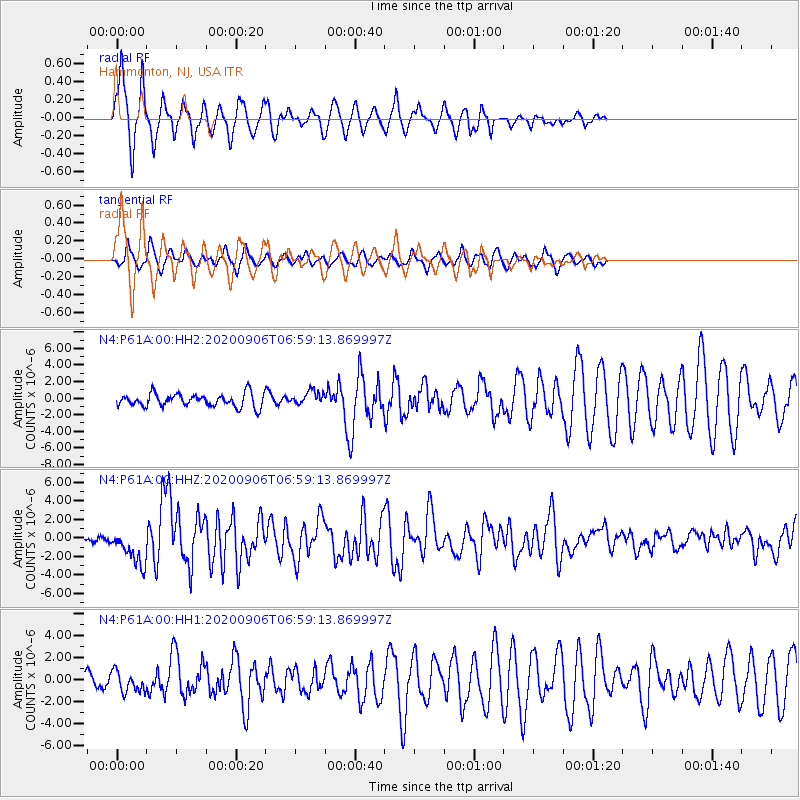
Signal To Noise
| Channel | StoN | STA | LTA |
| N4:P61A:00:HHZ:20200906T06:59:13.869997Z | 6.126443 | 1.9249064E-6 | 3.141964E-7 |
| N4:P61A:00:HH1:20200906T06:59:13.869997Z | 1.9160979 | 9.333401E-7 | 4.871046E-7 |
| N4:P61A:00:HH2:20200906T06:59:13.869997Z | 1.0799345 | 8.4708665E-7 | 7.843871E-7 |
| Arrivals |
| Ps | 4.4 SECOND |
| PpPs | 15 SECOND |
| PsPs/PpSs | 19 SECOND |


