You are here: Home > Network List > N4 - Central and EAstern US Network Stations List
> Station S51A Beattyville, KY, USA > Earthquake Result Viewer
S51A Beattyville, KY, USA - Earthquake Result Viewer
| Earthquake location: |
Central Mid-Atlantic Ridge |
| Earthquake latitude/longitude: |
7.7/-37.2 |
| Earthquake time(UTC): |
2020/09/06 (250) 06:51:19 GMT |
| Earthquake Depth: |
10 km |
| Earthquake Magnitude: |
6.7 Mww |
| Earthquake Catalog/Contributor: |
NEIC PDE/us |
|
| Network: |
N4 Central and EAstern US Network |
| Station: |
S51A Beattyville, KY, USA |
| Lat/Lon: |
37.64 N/83.59 W |
| Elevation: |
286 m |
|
| Distance: |
51.4 deg |
| Az: |
312.679 deg |
| Baz: |
113.386 deg |
| Ray Param: |
0.067432806 |
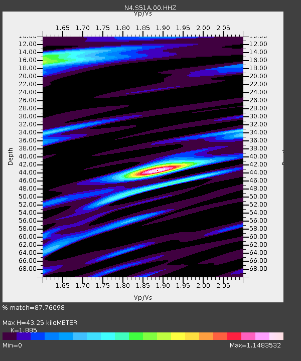
| Estimated Moho Depth: |
43.25 km |
| Estimated Crust Vp/Vs: |
1.88 |
| Assumed Crust Vp: |
6.476 km/s |
| Estimated Crust Vs: |
3.435 km/s |
| Estimated Crust Poisson's Ratio: |
0.30 |
|
| Radial Match: |
87.76098 % |
| Radial Bump: |
400 |
| Transverse Match: |
69.931305 % |
| Transverse Bump: |
400 |
| SOD ConfigId: |
22732711 |
| Insert Time: |
2020-09-20 07:14:00.205 +0000 |
| GWidth: |
2.5 |
| Max Bumps: |
400 |
| Tol: |
0.001 |
|

Signal To Noise
| Channel | StoN | STA | LTA |
| N4:S51A:00:HHZ:20200906T06:59:53.019991Z | 7.3115544 | 1.3128622E-6 | 1.7955993E-7 |
| N4:S51A:00:HH1:20200906T06:59:53.019991Z | 1.7159775 | 2.2007663E-7 | 1.2825147E-7 |
| N4:S51A:00:HH2:20200906T06:59:53.019991Z | 5.6425714 | 6.982929E-7 | 1.2375438E-7 |
| Arrivals |
| Ps | 6.2 SECOND |
| PpPs | 18 SECOND |
| PsPs/PpSs | 24 SECOND |


