You are here: Home > Network List > N4 - Central and EAstern US Network Stations List
> Station U38B Mount Pleasant Farm, Gravette, AR, USA > Earthquake Result Viewer
U38B Mount Pleasant Farm, Gravette, AR, USA - Earthquake Result Viewer
| Earthquake location: |
Central Mid-Atlantic Ridge |
| Earthquake latitude/longitude: |
7.7/-37.2 |
| Earthquake time(UTC): |
2020/09/06 (250) 06:51:19 GMT |
| Earthquake Depth: |
10 km |
| Earthquake Magnitude: |
6.7 Mww |
| Earthquake Catalog/Contributor: |
NEIC PDE/us |
|
| Network: |
N4 Central and EAstern US Network |
| Station: |
U38B Mount Pleasant Farm, Gravette, AR, USA |
| Lat/Lon: |
36.44 N/94.39 W |
| Elevation: |
389 m |
|
| Distance: |
59.2 deg |
| Az: |
307.927 deg |
| Baz: |
104.188 deg |
| Ray Param: |
0.062346786 |
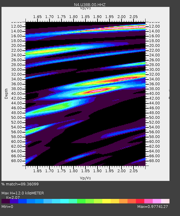
| Estimated Moho Depth: |
12.0 km |
| Estimated Crust Vp/Vs: |
2.07 |
| Assumed Crust Vp: |
6.53 km/s |
| Estimated Crust Vs: |
3.155 km/s |
| Estimated Crust Poisson's Ratio: |
0.35 |
|
| Radial Match: |
89.36099 % |
| Radial Bump: |
359 |
| Transverse Match: |
77.74981 % |
| Transverse Bump: |
400 |
| SOD ConfigId: |
22732711 |
| Insert Time: |
2020-09-20 07:14:18.625 +0000 |
| GWidth: |
2.5 |
| Max Bumps: |
400 |
| Tol: |
0.001 |
|

Signal To Noise
| Channel | StoN | STA | LTA |
| N4:U38B:00:HHZ:20200906T07:00:49.079989Z | 7.521739 | 1.0136772E-6 | 1.3476634E-7 |
| N4:U38B:00:HH1:20200906T07:00:49.079989Z | 1.3811209 | 1.1577808E-7 | 8.382907E-8 |
| N4:U38B:00:HH2:20200906T07:00:49.079989Z | 4.2436175 | 4.4814666E-7 | 1.0560487E-7 |
| Arrivals |
| Ps | 2.1 SECOND |
| PpPs | 5.4 SECOND |
| PsPs/PpSs | 7.5 SECOND |


