You are here: Home > Network List > N4 - Central and EAstern US Network Stations List
> Station V61A Roper, NC, USA > Earthquake Result Viewer
V61A Roper, NC, USA - Earthquake Result Viewer
| Earthquake location: |
Central Mid-Atlantic Ridge |
| Earthquake latitude/longitude: |
7.7/-37.2 |
| Earthquake time(UTC): |
2020/09/06 (250) 06:51:19 GMT |
| Earthquake Depth: |
10 km |
| Earthquake Magnitude: |
6.7 Mww |
| Earthquake Catalog/Contributor: |
NEIC PDE/us |
|
| Network: |
N4 Central and EAstern US Network |
| Station: |
V61A Roper, NC, USA |
| Lat/Lon: |
35.79 N/76.58 W |
| Elevation: |
4.0 m |
|
| Distance: |
45.5 deg |
| Az: |
313.744 deg |
| Baz: |
118.273 deg |
| Ray Param: |
0.07121802 |
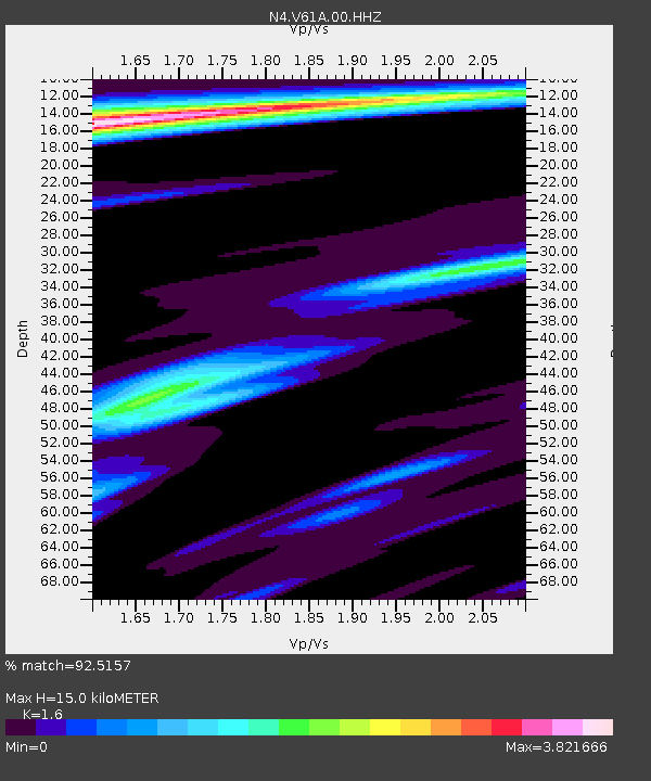
| Estimated Moho Depth: |
15.0 km |
| Estimated Crust Vp/Vs: |
1.60 |
| Assumed Crust Vp: |
6.565 km/s |
| Estimated Crust Vs: |
4.103 km/s |
| Estimated Crust Poisson's Ratio: |
0.18 |
|
| Radial Match: |
92.5157 % |
| Radial Bump: |
339 |
| Transverse Match: |
63.95723 % |
| Transverse Bump: |
396 |
| SOD ConfigId: |
22732711 |
| Insert Time: |
2020-09-20 07:14:29.552 +0000 |
| GWidth: |
2.5 |
| Max Bumps: |
400 |
| Tol: |
0.001 |
|

Signal To Noise
| Channel | StoN | STA | LTA |
| N4:V61A:00:HHZ:20200906T06:59:07.82001Z | 4.9200234 | 1.8664146E-6 | 3.7935075E-7 |
| N4:V61A:00:HH1:20200906T06:59:07.82001Z | 1.2019526 | 6.87046E-7 | 5.7160827E-7 |
| N4:V61A:00:HH2:20200906T06:59:07.82001Z | 2.0452282 | 1.1334532E-6 | 5.54194E-7 |
| Arrivals |
| Ps | 1.5 SECOND |
| PpPs | 5.5 SECOND |
| PsPs/PpSs | 7.0 SECOND |


