You are here: Home > Network List > NM - Cooperative New Madrid Seismic Network Stations List
> Station LPAR Lepanto,AR > Earthquake Result Viewer
LPAR Lepanto,AR - Earthquake Result Viewer
| Earthquake location: |
Central Mid-Atlantic Ridge |
| Earthquake latitude/longitude: |
7.7/-37.2 |
| Earthquake time(UTC): |
2020/09/06 (250) 06:51:19 GMT |
| Earthquake Depth: |
10 km |
| Earthquake Magnitude: |
6.7 Mww |
| Earthquake Catalog/Contributor: |
NEIC PDE/us |
|
| Network: |
NM Cooperative New Madrid Seismic Network |
| Station: |
LPAR Lepanto,AR |
| Lat/Lon: |
35.60 N/90.30 W |
| Elevation: |
67 m |
|
| Distance: |
55.8 deg |
| Az: |
308.016 deg |
| Baz: |
106.629 deg |
| Ray Param: |
0.06457343 |
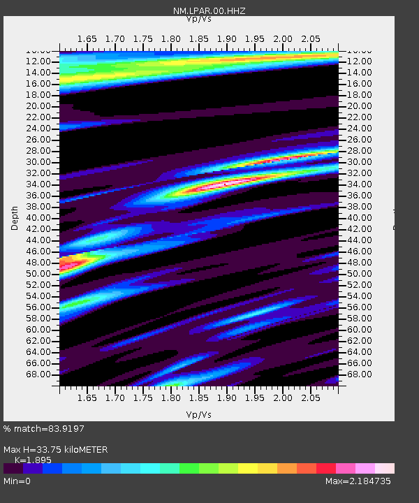
| Estimated Moho Depth: |
33.75 km |
| Estimated Crust Vp/Vs: |
1.89 |
| Assumed Crust Vp: |
6.273 km/s |
| Estimated Crust Vs: |
3.31 km/s |
| Estimated Crust Poisson's Ratio: |
0.31 |
|
| Radial Match: |
83.9197 % |
| Radial Bump: |
391 |
| Transverse Match: |
63.964508 % |
| Transverse Bump: |
400 |
| SOD ConfigId: |
22732711 |
| Insert Time: |
2020-09-20 07:15:16.970 +0000 |
| GWidth: |
2.5 |
| Max Bumps: |
400 |
| Tol: |
0.001 |
|

Signal To Noise
| Channel | StoN | STA | LTA |
| NM:LPAR:00:HHZ:20200906T07:00:25.06003Z | 5.505853 | 1.1761479E-6 | 2.1361775E-7 |
| NM:LPAR:00:HHN:20200906T07:00:25.06003Z | 0.81756806 | 5.8415856E-7 | 7.145075E-7 |
| NM:LPAR:00:HHE:20200906T07:00:25.06003Z | 1.0437728 | 9.1562106E-7 | 8.7722253E-7 |
| Arrivals |
| Ps | 5.0 SECOND |
| PpPs | 15 SECOND |
| PsPs/PpSs | 20 SECOND |


