You are here: Home > Network List > O2 - Oklahoma Consolidated Temporary Seismic Networks Stations List
> Station MRSH Marshall, Oklahoma, USA > Earthquake Result Viewer
MRSH Marshall, Oklahoma, USA - Earthquake Result Viewer
| Earthquake location: |
Central Mid-Atlantic Ridge |
| Earthquake latitude/longitude: |
7.7/-37.2 |
| Earthquake time(UTC): |
2020/09/06 (250) 06:51:19 GMT |
| Earthquake Depth: |
10 km |
| Earthquake Magnitude: |
6.7 Mww |
| Earthquake Catalog/Contributor: |
NEIC PDE/us |
|
| Network: |
O2 Oklahoma Consolidated Temporary Seismic Networks |
| Station: |
MRSH Marshall, Oklahoma, USA |
| Lat/Lon: |
36.13 N/97.70 W |
| Elevation: |
309 m |
|
| Distance: |
61.7 deg |
| Az: |
306.895 deg |
| Baz: |
101.729 deg |
| Ray Param: |
0.06068423 |
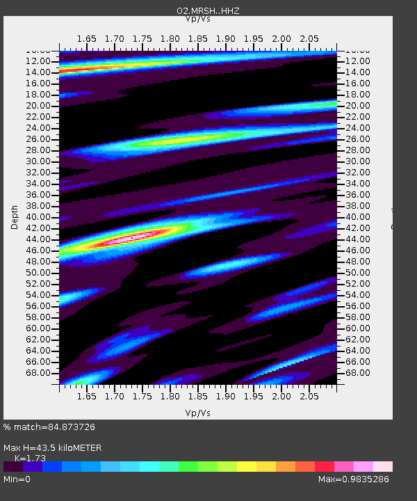
| Estimated Moho Depth: |
43.5 km |
| Estimated Crust Vp/Vs: |
1.73 |
| Assumed Crust Vp: |
6.483 km/s |
| Estimated Crust Vs: |
3.747 km/s |
| Estimated Crust Poisson's Ratio: |
0.25 |
|
| Radial Match: |
84.873726 % |
| Radial Bump: |
330 |
| Transverse Match: |
81.6436 % |
| Transverse Bump: |
400 |
| SOD ConfigId: |
22732711 |
| Insert Time: |
2020-09-20 07:17:17.870 +0000 |
| GWidth: |
2.5 |
| Max Bumps: |
400 |
| Tol: |
0.001 |
|

Signal To Noise
| Channel | StoN | STA | LTA |
| O2:MRSH: :HHZ:20200906T07:01:06.384981Z | 5.069207 | 1.0805775E-6 | 2.1316498E-7 |
| O2:MRSH: :HHN:20200906T07:01:06.384981Z | 1.365511 | 1.7812005E-7 | 1.3044205E-7 |
| O2:MRSH: :HHE:20200906T07:01:06.384981Z | 2.371704 | 5.93587E-7 | 2.502787E-7 |
| Arrivals |
| Ps | 5.1 SECOND |
| PpPs | 17 SECOND |
| PsPs/PpSs | 23 SECOND |


