You are here: Home > Network List > O2 - Oklahoma Consolidated Temporary Seismic Networks Stations List
> Station SC10 Scott, Oklahoma, USA > Earthquake Result Viewer
SC10 Scott, Oklahoma, USA - Earthquake Result Viewer
| Earthquake location: |
Central Mid-Atlantic Ridge |
| Earthquake latitude/longitude: |
7.7/-37.2 |
| Earthquake time(UTC): |
2020/09/06 (250) 06:51:19 GMT |
| Earthquake Depth: |
10 km |
| Earthquake Magnitude: |
6.7 Mww |
| Earthquake Catalog/Contributor: |
NEIC PDE/us |
|
| Network: |
O2 Oklahoma Consolidated Temporary Seismic Networks |
| Station: |
SC10 Scott, Oklahoma, USA |
| Lat/Lon: |
35.42 N/98.27 W |
| Elevation: |
502 m |
|
| Distance: |
62.1 deg |
| Az: |
306.003 deg |
| Baz: |
100.974 deg |
| Ray Param: |
0.06047833 |
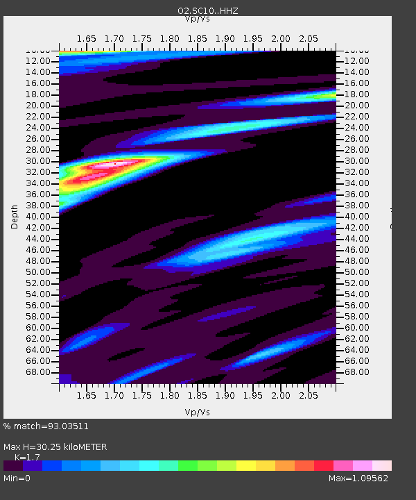
| Estimated Moho Depth: |
30.25 km |
| Estimated Crust Vp/Vs: |
1.70 |
| Assumed Crust Vp: |
6.315 km/s |
| Estimated Crust Vs: |
3.715 km/s |
| Estimated Crust Poisson's Ratio: |
0.24 |
|
| Radial Match: |
93.03511 % |
| Radial Bump: |
364 |
| Transverse Match: |
78.84837 % |
| Transverse Bump: |
400 |
| SOD ConfigId: |
22732711 |
| Insert Time: |
2020-09-20 07:17:48.927 +0000 |
| GWidth: |
2.5 |
| Max Bumps: |
400 |
| Tol: |
0.001 |
|

Signal To Noise
| Channel | StoN | STA | LTA |
| O2:SC10: :HHZ:20200906T07:01:08.524996Z | 7.0622144 | 1.2699518E-6 | 1.7982345E-7 |
| O2:SC10: :HHN:20200906T07:01:08.524996Z | 1.3591594 | 3.465971E-7 | 2.5500842E-7 |
| O2:SC10: :HHE:20200906T07:01:08.524996Z | 1.658129 | 5.995072E-7 | 3.6155643E-7 |
| Arrivals |
| Ps | 3.5 SECOND |
| PpPs | 12 SECOND |
| PsPs/PpSs | 16 SECOND |


