You are here: Home > Network List > O2 - Oklahoma Consolidated Temporary Seismic Networks Stations List
> Station SC14 Walters, Oklahoma, USA > Earthquake Result Viewer
SC14 Walters, Oklahoma, USA - Earthquake Result Viewer
| Earthquake location: |
Central Mid-Atlantic Ridge |
| Earthquake latitude/longitude: |
7.7/-37.2 |
| Earthquake time(UTC): |
2020/09/06 (250) 06:51:19 GMT |
| Earthquake Depth: |
10 km |
| Earthquake Magnitude: |
6.7 Mww |
| Earthquake Catalog/Contributor: |
NEIC PDE/us |
|
| Network: |
O2 Oklahoma Consolidated Temporary Seismic Networks |
| Station: |
SC14 Walters, Oklahoma, USA |
| Lat/Lon: |
34.45 N/98.24 W |
| Elevation: |
339 m |
|
| Distance: |
61.9 deg |
| Az: |
304.93 deg |
| Baz: |
100.485 deg |
| Ray Param: |
0.06060844 |
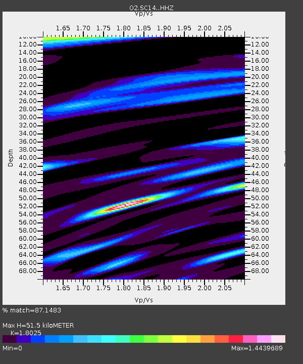
| Estimated Moho Depth: |
51.5 km |
| Estimated Crust Vp/Vs: |
1.80 |
| Assumed Crust Vp: |
6.315 km/s |
| Estimated Crust Vs: |
3.504 km/s |
| Estimated Crust Poisson's Ratio: |
0.28 |
|
| Radial Match: |
87.1483 % |
| Radial Bump: |
314 |
| Transverse Match: |
83.52588 % |
| Transverse Bump: |
399 |
| SOD ConfigId: |
22732711 |
| Insert Time: |
2020-09-20 07:17:54.437 +0000 |
| GWidth: |
2.5 |
| Max Bumps: |
400 |
| Tol: |
0.001 |
|

Signal To Noise
| Channel | StoN | STA | LTA |
| O2:SC14: :HHZ:20200906T07:01:07.165011Z | 6.506477 | 8.9266126E-7 | 1.371958E-7 |
| O2:SC14: :HHN:20200906T07:01:07.165011Z | 0.7277118 | 1.6919032E-7 | 2.324963E-7 |
| O2:SC14: :HHE:20200906T07:01:07.165011Z | 2.2338798 | 4.5553455E-7 | 2.039208E-7 |
| Arrivals |
| Ps | 6.8 SECOND |
| PpPs | 22 SECOND |
| PsPs/PpSs | 29 SECOND |


