You are here: Home > Network List > OH - Ohio Seismic Network Stations List
> Station KLOH Kiser Lake State Park Ohio > Earthquake Result Viewer
KLOH Kiser Lake State Park Ohio - Earthquake Result Viewer
| Earthquake location: |
Central Mid-Atlantic Ridge |
| Earthquake latitude/longitude: |
7.7/-37.2 |
| Earthquake time(UTC): |
2020/09/06 (250) 06:51:19 GMT |
| Earthquake Depth: |
10 km |
| Earthquake Magnitude: |
6.7 Mww |
| Earthquake Catalog/Contributor: |
NEIC PDE/us |
|
| Network: |
OH Ohio Seismic Network |
| Station: |
KLOH Kiser Lake State Park Ohio |
| Lat/Lon: |
40.20 N/83.97 W |
| Elevation: |
350 m |
|
| Distance: |
52.7 deg |
| Az: |
315.481 deg |
| Baz: |
114.876 deg |
| Ray Param: |
0.06657794 |
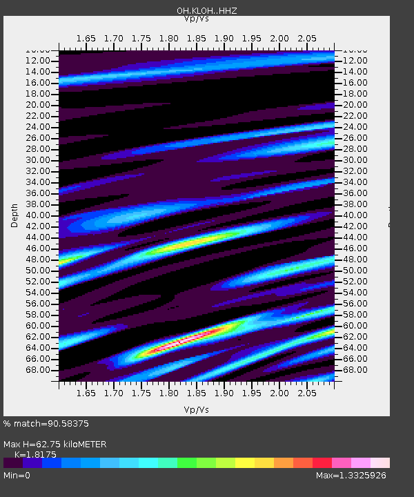
| Estimated Moho Depth: |
62.75 km |
| Estimated Crust Vp/Vs: |
1.82 |
| Assumed Crust Vp: |
6.498 km/s |
| Estimated Crust Vs: |
3.575 km/s |
| Estimated Crust Poisson's Ratio: |
0.28 |
|
| Radial Match: |
90.58375 % |
| Radial Bump: |
400 |
| Transverse Match: |
74.94448 % |
| Transverse Bump: |
400 |
| SOD ConfigId: |
22732711 |
| Insert Time: |
2020-09-20 07:18:20.590 +0000 |
| GWidth: |
2.5 |
| Max Bumps: |
400 |
| Tol: |
0.001 |
|

Signal To Noise
| Channel | StoN | STA | LTA |
| OH:KLOH: :HHZ:20200906T07:00:02.749972Z | 4.880561 | 1.0799589E-6 | 2.2127763E-7 |
| OH:KLOH: :HHN:20200906T07:00:02.749972Z | 1.5424218 | 2.2578249E-7 | 1.4638181E-7 |
| OH:KLOH: :HHE:20200906T07:00:02.749972Z | 1.8340783 | 4.5538712E-7 | 2.4829208E-7 |
| Arrivals |
| Ps | 8.3 SECOND |
| PpPs | 26 SECOND |
| PsPs/PpSs | 34 SECOND |


