You are here: Home > Network List > PO - Portable Observatories for Lithospheric Analysis and Research Investigating Seis Stations List
> Station NMSQ Nemaska Station, QC, CA > Earthquake Result Viewer
NMSQ Nemaska Station, QC, CA - Earthquake Result Viewer
| Earthquake location: |
Central Mid-Atlantic Ridge |
| Earthquake latitude/longitude: |
7.7/-37.2 |
| Earthquake time(UTC): |
2020/09/06 (250) 06:51:19 GMT |
| Earthquake Depth: |
10 km |
| Earthquake Magnitude: |
6.7 Mww |
| Earthquake Catalog/Contributor: |
NEIC PDE/us |
|
| Network: |
PO Portable Observatories for Lithospheric Analysis and Research Investigating Seis |
| Station: |
NMSQ Nemaska Station, QC, CA |
| Lat/Lon: |
51.71 N/76.02 W |
| Elevation: |
275 m |
|
| Distance: |
54.2 deg |
| Az: |
331.276 deg |
| Baz: |
130.04 deg |
| Ray Param: |
0.06559502 |
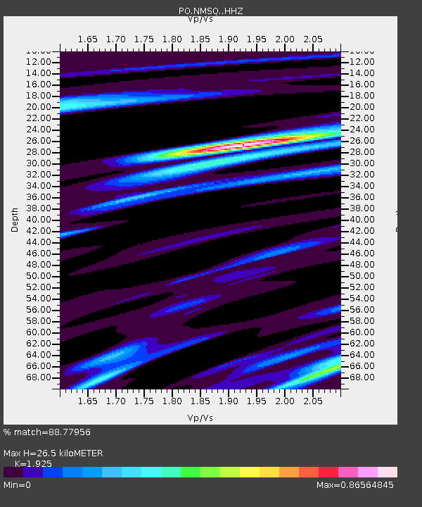
| Estimated Moho Depth: |
26.5 km |
| Estimated Crust Vp/Vs: |
1.92 |
| Assumed Crust Vp: |
6.459 km/s |
| Estimated Crust Vs: |
3.356 km/s |
| Estimated Crust Poisson's Ratio: |
0.32 |
|
| Radial Match: |
88.77956 % |
| Radial Bump: |
311 |
| Transverse Match: |
63.43688 % |
| Transverse Bump: |
375 |
| SOD ConfigId: |
22732711 |
| Insert Time: |
2020-09-20 07:20:33.396 +0000 |
| GWidth: |
2.5 |
| Max Bumps: |
400 |
| Tol: |
0.001 |
|

Signal To Noise
| Channel | StoN | STA | LTA |
| PO:NMSQ: :HHZ:20200906T07:00:13.746004Z | 3.3489952 | 1.973438E-6 | 5.892627E-7 |
| PO:NMSQ: :HHN:20200906T07:00:13.746004Z | 2.727075 | 6.518102E-7 | 2.3901438E-7 |
| PO:NMSQ: :HHE:20200906T07:00:13.746004Z | 2.1123207 | 7.153693E-7 | 3.3866513E-7 |
| Arrivals |
| Ps | 4.0 SECOND |
| PpPs | 11 SECOND |
| PsPs/PpSs | 15 SECOND |


