You are here: Home > Network List > TA - USArray Transportable Network (new EarthScope stations) Stations List
> Station I30M Mount Dempster, Yukon, CAN > Earthquake Result Viewer
I30M Mount Dempster, Yukon, CAN - Earthquake Result Viewer
| Earthquake location: |
Central Mid-Atlantic Ridge |
| Earthquake latitude/longitude: |
7.7/-37.2 |
| Earthquake time(UTC): |
2020/09/06 (250) 06:51:19 GMT |
| Earthquake Depth: |
10 km |
| Earthquake Magnitude: |
6.7 Mww |
| Earthquake Catalog/Contributor: |
NEIC PDE/us |
|
| Network: |
TA USArray Transportable Network (new EarthScope stations) |
| Station: |
I30M Mount Dempster, Yukon, CAN |
| Lat/Lon: |
65.22 N/136.38 W |
| Elevation: |
1399 m |
|
| Distance: |
86.9 deg |
| Az: |
335.376 deg |
| Baz: |
78.498 deg |
| Ray Param: |
0.043719176 |
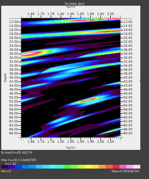
| Estimated Moho Depth: |
28.0 km |
| Estimated Crust Vp/Vs: |
1.62 |
| Assumed Crust Vp: |
6.566 km/s |
| Estimated Crust Vs: |
4.053 km/s |
| Estimated Crust Poisson's Ratio: |
0.19 |
|
| Radial Match: |
85.48179 % |
| Radial Bump: |
400 |
| Transverse Match: |
76.4738 % |
| Transverse Bump: |
400 |
| SOD ConfigId: |
22732711 |
| Insert Time: |
2020-09-20 07:23:05.767 +0000 |
| GWidth: |
2.5 |
| Max Bumps: |
400 |
| Tol: |
0.001 |
|
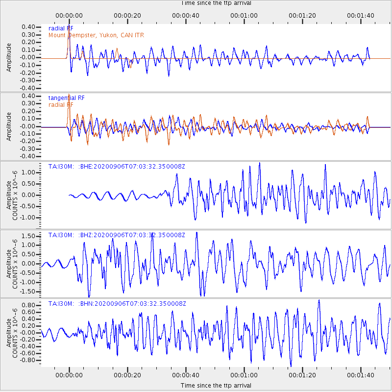
Signal To Noise
| Channel | StoN | STA | LTA |
| TA:I30M: :BHZ:20200906T07:03:32.350008Z | 4.287593 | 4.6460718E-7 | 1.08360844E-7 |
| TA:I30M: :BHN:20200906T07:03:32.350008Z | 0.902461 | 6.994271E-8 | 7.750219E-8 |
| TA:I30M: :BHE:20200906T07:03:32.350008Z | 1.1488754 | 1.2517752E-7 | 1.0895657E-7 |
| Arrivals |
| Ps | 2.7 SECOND |
| PpPs | 11 SECOND |
| PsPs/PpSs | 14 SECOND |


