You are here: Home > Network List > TA - USArray Transportable Network (new EarthScope stations) Stations List
> Station R31K City Hall, Gustavus, AK, USA > Earthquake Result Viewer
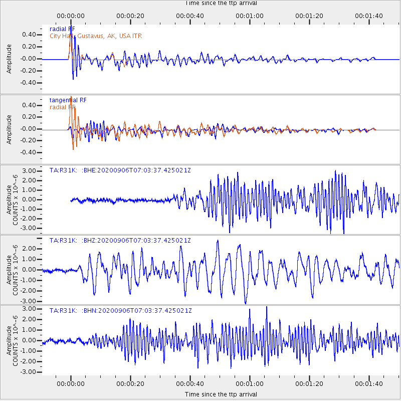
R31K City Hall, Gustavus, AK, USA - Earthquake Result Viewer
*The percent match for this event was below the threshold and hence no stack was calculated.
| Earthquake location: |
Central Mid-Atlantic Ridge |
| Earthquake latitude/longitude: |
7.7/-37.2 |
| Earthquake time(UTC): |
2020/09/06 (250) 06:51:19 GMT |
| Earthquake Depth: |
10 km |
| Earthquake Magnitude: |
6.7 Mww |
| Earthquake Catalog/Contributor: |
NEIC PDE/us |
|
| Network: |
TA USArray Transportable Network (new EarthScope stations) |
| Station: |
R31K City Hall, Gustavus, AK, USA |
| Lat/Lon: |
58.41 N/135.74 W |
| Elevation: |
15 m |
|
| Distance: |
88.0 deg |
| Az: |
328.61 deg |
| Baz: |
78.755 deg |
| Ray Param: |
$rayparam |
*The percent match for this event was below the threshold and hence was not used in the summary stack. |
|
| Radial Match: |
72.41061 % |
| Radial Bump: |
400 |
| Transverse Match: |
63.08706 % |
| Transverse Bump: |
400 |
| SOD ConfigId: |
22732711 |
| Insert Time: |
2020-09-20 07:23:38.975 +0000 |
| GWidth: |
2.5 |
| Max Bumps: |
400 |
| Tol: |
0.001 |
|
Signal To Noise
| Channel | StoN | STA | LTA |
| TA:R31K: :BHZ:20200906T07:03:37.425021Z | 3.1377265 | 3.762066E-7 | 1.1989783E-7 |
| TA:R31K: :BHN:20200906T07:03:37.425021Z | 1.1492044 | 1.5920457E-7 | 1.385346E-7 |
| TA:R31K: :BHE:20200906T07:03:37.425021Z | 1.4471223 | 1.6836803E-7 | 1.1634679E-7 |
| Arrivals |
| Ps | |
| PpPs | |
| PsPs/PpSs | |


