You are here: Home > Network List > TX - Texas Seismological Network Stations List
> Station MB05 Klondike > Earthquake Result Viewer
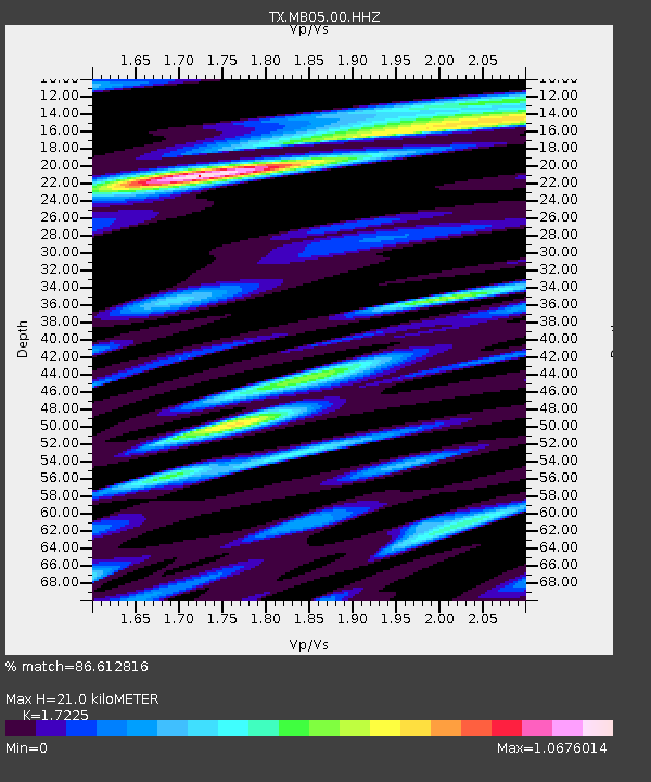
MB05 Klondike - Earthquake Result Viewer
| Earthquake location: |
Central Mid-Atlantic Ridge |
| Earthquake latitude/longitude: |
7.7/-37.2 |
| Earthquake time(UTC): |
2020/09/06 (250) 06:51:19 GMT |
| Earthquake Depth: |
10 km |
| Earthquake Magnitude: |
6.7 Mww |
| Earthquake Catalog/Contributor: |
NEIC PDE/us |
|
| Network: |
TX Texas Seismological Network |
| Station: |
MB05 Klondike |
| Lat/Lon: |
32.63 N/101.86 W |
| Elevation: |
882 m |
|
| Distance: |
64.6 deg |
| Az: |
302.392 deg |
| Baz: |
97.351 deg |
| Ray Param: |
0.058846835 |
| Estimated Moho Depth: |
21.0 km |
| Estimated Crust Vp/Vs: |
1.72 |
| Assumed Crust Vp: |
6.426 km/s |
| Estimated Crust Vs: |
3.731 km/s |
| Estimated Crust Poisson's Ratio: |
0.25 |
|
| Radial Match: |
86.612816 % |
| Radial Bump: |
400 |
| Transverse Match: |
85.093315 % |
| Transverse Bump: |
400 |
| SOD ConfigId: |
22732711 |
| Insert Time: |
2020-09-20 07:24:53.275 +0000 |
| GWidth: |
2.5 |
| Max Bumps: |
400 |
| Tol: |
0.001 |
|

Signal To Noise
| Channel | StoN | STA | LTA |
| TX:MB05:00:HHZ:20200906T07:01:25.050021Z | 5.3610787 | 4.043333E-7 | 7.542013E-8 |
| TX:MB05:00:HH1:20200906T07:01:25.050021Z | 1.6539583 | 1.366423E-7 | 8.261532E-8 |
| TX:MB05:00:HH2:20200906T07:01:25.050021Z | 2.1054728 | 1.9777815E-7 | 9.393527E-8 |
| Arrivals |
| Ps | 2.5 SECOND |
| PpPs | 8.5 SECOND |
| PsPs/PpSs | 11 SECOND |


