You are here: Home > Network List > UW - Pacific Northwest Regional Seismic Network Stations List
> Station SNI2 Snively Ranch 2, Hanford, WA, USA > Earthquake Result Viewer
SNI2 Snively Ranch 2, Hanford, WA, USA - Earthquake Result Viewer
| Earthquake location: |
Central Mid-Atlantic Ridge |
| Earthquake latitude/longitude: |
7.7/-37.2 |
| Earthquake time(UTC): |
2020/09/06 (250) 06:51:19 GMT |
| Earthquake Depth: |
10 km |
| Earthquake Magnitude: |
6.7 Mww |
| Earthquake Catalog/Contributor: |
NEIC PDE/us |
|
| Network: |
UW Pacific Northwest Regional Seismic Network |
| Station: |
SNI2 Snively Ranch 2, Hanford, WA, USA |
| Lat/Lon: |
46.46 N/119.66 W |
| Elevation: |
267 m |
|
| Distance: |
79.3 deg |
| Az: |
315.78 deg |
| Baz: |
90.136 deg |
| Ray Param: |
0.0490852 |
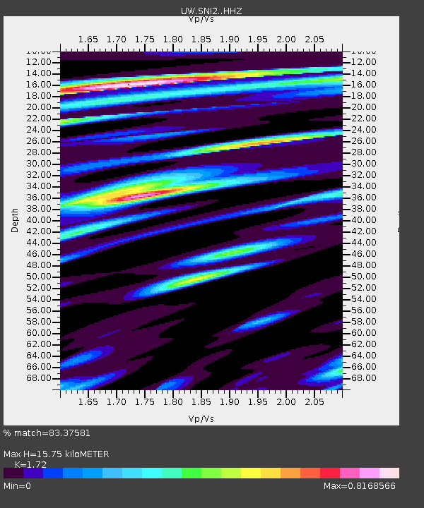
| Estimated Moho Depth: |
15.75 km |
| Estimated Crust Vp/Vs: |
1.72 |
| Assumed Crust Vp: |
6.419 km/s |
| Estimated Crust Vs: |
3.732 km/s |
| Estimated Crust Poisson's Ratio: |
0.24 |
|
| Radial Match: |
83.37581 % |
| Radial Bump: |
400 |
| Transverse Match: |
70.19077 % |
| Transverse Bump: |
400 |
| SOD ConfigId: |
22732711 |
| Insert Time: |
2020-09-20 07:29:59.500 +0000 |
| GWidth: |
2.5 |
| Max Bumps: |
400 |
| Tol: |
0.001 |
|

Signal To Noise
| Channel | StoN | STA | LTA |
| UW:SNI2: :HHZ:20200906T07:02:53.040011Z | 3.4333675 | 6.019557E-7 | 1.7532516E-7 |
| UW:SNI2: :HHN:20200906T07:02:53.040011Z | 1.3016793 | 1.6562187E-7 | 1.2723709E-7 |
| UW:SNI2: :HHE:20200906T07:02:53.040011Z | 2.2077935 | 2.777531E-7 | 1.2580574E-7 |
| Arrivals |
| Ps | 1.8 SECOND |
| PpPs | 6.5 SECOND |
| PsPs/PpSs | 8.3 SECOND |


