You are here: Home > Network List > TA - USArray Transportable Network (new EarthScope stations) Stations List
> Station G21K Allakaket, AK, USA > Earthquake Result Viewer
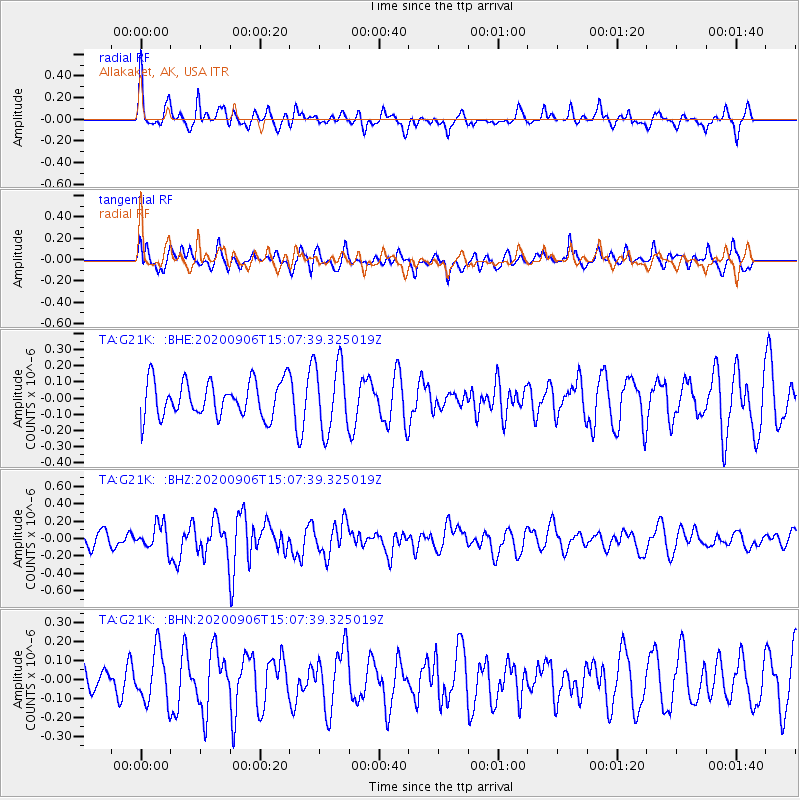
G21K Allakaket, AK, USA - Earthquake Result Viewer
*The percent match for this event was below the threshold and hence no stack was calculated.
| Earthquake location: |
Tonga Islands |
| Earthquake latitude/longitude: |
-20.7/-173.6 |
| Earthquake time(UTC): |
2020/09/06 (250) 14:55:19 GMT |
| Earthquake Depth: |
10 km |
| Earthquake Magnitude: |
5.5 mww |
| Earthquake Catalog/Contributor: |
NEIC PDE/us |
|
| Network: |
TA USArray Transportable Network (new EarthScope stations) |
| Station: |
G21K Allakaket, AK, USA |
| Lat/Lon: |
66.52 N/153.51 W |
| Elevation: |
446 m |
|
| Distance: |
88.3 deg |
| Az: |
7.906 deg |
| Baz: |
198.743 deg |
| Ray Param: |
$rayparam |
*The percent match for this event was below the threshold and hence was not used in the summary stack. |
|
| Radial Match: |
70.402885 % |
| Radial Bump: |
398 |
| Transverse Match: |
57.96422 % |
| Transverse Bump: |
400 |
| SOD ConfigId: |
22732711 |
| Insert Time: |
2020-09-20 15:08:37.587 +0000 |
| GWidth: |
2.5 |
| Max Bumps: |
400 |
| Tol: |
0.001 |
|
Signal To Noise
| Channel | StoN | STA | LTA |
| TA:G21K: :BHZ:20200906T15:07:39.325019Z | 1.5250312 | 1.438541E-7 | 9.432863E-8 |
| TA:G21K: :BHN:20200906T15:07:39.325019Z | 1.3502222 | 1.3791713E-7 | 1.0214402E-7 |
| TA:G21K: :BHE:20200906T15:07:39.325019Z | 1.8920445 | 2.0839435E-7 | 1.10142416E-7 |
| Arrivals |
| Ps | |
| PpPs | |
| PsPs/PpSs | |


