You are here: Home > Network List > AK - Alaska Regional Network Stations List
> Station HIN Hinchinbrook, AK, USA > Earthquake Result Viewer
HIN Hinchinbrook, AK, USA - Earthquake Result Viewer
| Earthquake location: |
Mindanao, Philippines |
| Earthquake latitude/longitude: |
6.3/125.8 |
| Earthquake time(UTC): |
2020/09/06 (250) 15:23:43 GMT |
| Earthquake Depth: |
120 km |
| Earthquake Magnitude: |
6.3 mww |
| Earthquake Catalog/Contributor: |
NEIC PDE/us |
|
| Network: |
AK Alaska Regional Network |
| Station: |
HIN Hinchinbrook, AK, USA |
| Lat/Lon: |
60.40 N/146.50 W |
| Elevation: |
623 m |
|
| Distance: |
83.4 deg |
| Az: |
29.958 deg |
| Baz: |
271.081 deg |
| Ray Param: |
0.045918744 |
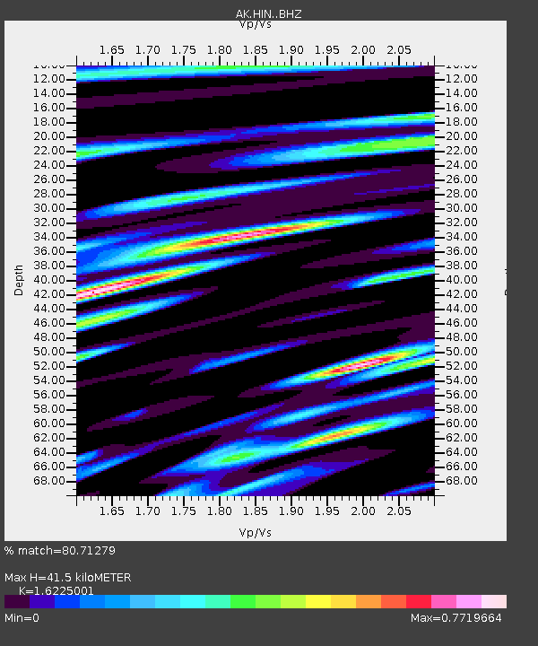
| Estimated Moho Depth: |
41.5 km |
| Estimated Crust Vp/Vs: |
1.62 |
| Assumed Crust Vp: |
6.566 km/s |
| Estimated Crust Vs: |
4.047 km/s |
| Estimated Crust Poisson's Ratio: |
0.19 |
|
| Radial Match: |
80.71279 % |
| Radial Bump: |
400 |
| Transverse Match: |
83.193474 % |
| Transverse Bump: |
400 |
| SOD ConfigId: |
22732711 |
| Insert Time: |
2020-09-20 15:25:29.488 +0000 |
| GWidth: |
2.5 |
| Max Bumps: |
400 |
| Tol: |
0.001 |
|

Signal To Noise
| Channel | StoN | STA | LTA |
| AK:HIN: :BHZ:20200906T15:35:26.148Z | 16.330807 | 2.2190395E-6 | 1.3588058E-7 |
| AK:HIN: :BHN:20200906T15:35:26.148Z | 1.2910349 | 2.2871899E-7 | 1.7715941E-7 |
| AK:HIN: :BHE:20200906T15:35:26.148Z | 3.7217455 | 6.8704367E-7 | 1.8460254E-7 |
| Arrivals |
| Ps | 4.0 SECOND |
| PpPs | 16 SECOND |
| PsPs/PpSs | 20 SECOND |


