You are here: Home > Network List > AK - Alaska Regional Network Stations List
> Station K20K Telida, AK, USA > Earthquake Result Viewer
K20K Telida, AK, USA - Earthquake Result Viewer
| Earthquake location: |
Mindanao, Philippines |
| Earthquake latitude/longitude: |
6.3/125.8 |
| Earthquake time(UTC): |
2020/09/06 (250) 15:23:43 GMT |
| Earthquake Depth: |
120 km |
| Earthquake Magnitude: |
6.3 mww |
| Earthquake Catalog/Contributor: |
NEIC PDE/us |
|
| Network: |
AK Alaska Regional Network |
| Station: |
K20K Telida, AK, USA |
| Lat/Lon: |
63.36 N/154.07 W |
| Elevation: |
548 m |
|
| Distance: |
80.0 deg |
| Az: |
26.808 deg |
| Baz: |
263.959 deg |
| Ray Param: |
0.048312962 |
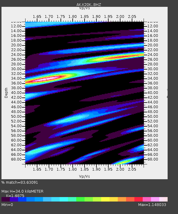
| Estimated Moho Depth: |
34.0 km |
| Estimated Crust Vp/Vs: |
1.69 |
| Assumed Crust Vp: |
6.438 km/s |
| Estimated Crust Vs: |
3.815 km/s |
| Estimated Crust Poisson's Ratio: |
0.23 |
|
| Radial Match: |
83.63091 % |
| Radial Bump: |
379 |
| Transverse Match: |
67.75979 % |
| Transverse Bump: |
364 |
| SOD ConfigId: |
22732711 |
| Insert Time: |
2020-09-20 15:25:45.109 +0000 |
| GWidth: |
2.5 |
| Max Bumps: |
400 |
| Tol: |
0.001 |
|

Signal To Noise
| Channel | StoN | STA | LTA |
| AK:K20K: :BHZ:20200906T15:35:08.100026Z | 6.8458953 | 1.0278098E-6 | 1.501352E-7 |
| AK:K20K: :BHN:20200906T15:35:08.100026Z | 0.66500443 | 1.2832609E-7 | 1.929703E-7 |
| AK:K20K: :BHE:20200906T15:35:08.100026Z | 2.9568293 | 4.691546E-7 | 1.5866814E-7 |
| Arrivals |
| Ps | 3.7 SECOND |
| PpPs | 14 SECOND |
| PsPs/PpSs | 18 SECOND |


