You are here: Home > Network List > AK - Alaska Regional Network Stations List
> Station YAH Yahtse, AK, USA > Earthquake Result Viewer
YAH Yahtse, AK, USA - Earthquake Result Viewer
| Earthquake location: |
Mindanao, Philippines |
| Earthquake latitude/longitude: |
6.3/125.8 |
| Earthquake time(UTC): |
2020/09/06 (250) 15:23:43 GMT |
| Earthquake Depth: |
120 km |
| Earthquake Magnitude: |
6.3 mww |
| Earthquake Catalog/Contributor: |
NEIC PDE/us |
|
| Network: |
AK Alaska Regional Network |
| Station: |
YAH Yahtse, AK, USA |
| Lat/Lon: |
60.36 N/141.75 W |
| Elevation: |
2125 m |
|
| Distance: |
85.8 deg |
| Az: |
29.866 deg |
| Baz: |
275.198 deg |
| Ray Param: |
0.044252396 |
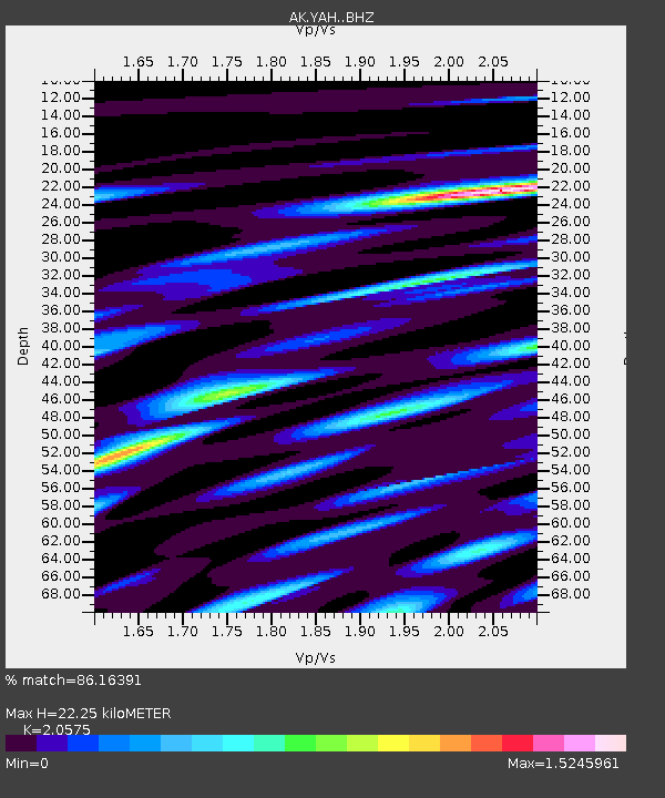
| Estimated Moho Depth: |
22.25 km |
| Estimated Crust Vp/Vs: |
2.06 |
| Assumed Crust Vp: |
6.566 km/s |
| Estimated Crust Vs: |
3.191 km/s |
| Estimated Crust Poisson's Ratio: |
0.35 |
|
| Radial Match: |
86.16391 % |
| Radial Bump: |
400 |
| Transverse Match: |
86.59146 % |
| Transverse Bump: |
400 |
| SOD ConfigId: |
22732711 |
| Insert Time: |
2020-09-20 15:27:15.174 +0000 |
| GWidth: |
2.5 |
| Max Bumps: |
400 |
| Tol: |
0.001 |
|

Signal To Noise
| Channel | StoN | STA | LTA |
| AK:YAH: :BHZ:20200906T15:35:37.947988Z | 3.9985948 | 7.547675E-7 | 1.887582E-7 |
| AK:YAH: :BHN:20200906T15:35:37.947988Z | 1.1154511 | 1.8985489E-7 | 1.7020459E-7 |
| AK:YAH: :BHE:20200906T15:35:37.947988Z | 2.926247 | 3.4795335E-7 | 1.1890772E-7 |
| Arrivals |
| Ps | 3.7 SECOND |
| PpPs | 10 SECOND |
| PsPs/PpSs | 14 SECOND |


