You are here: Home > Network List > TA - USArray Transportable Network (new EarthScope stations) Stations List
> Station B18K Kokolik River, AK, USA > Earthquake Result Viewer
B18K Kokolik River, AK, USA - Earthquake Result Viewer
| Earthquake location: |
Mindanao, Philippines |
| Earthquake latitude/longitude: |
6.3/125.8 |
| Earthquake time(UTC): |
2020/09/06 (250) 15:23:43 GMT |
| Earthquake Depth: |
120 km |
| Earthquake Magnitude: |
6.3 mww |
| Earthquake Catalog/Contributor: |
NEIC PDE/us |
|
| Network: |
TA USArray Transportable Network (new EarthScope stations) |
| Station: |
B18K Kokolik River, AK, USA |
| Lat/Lon: |
69.36 N/161.80 W |
| Elevation: |
222 m |
|
| Distance: |
78.0 deg |
| Az: |
20.208 deg |
| Baz: |
255.61 deg |
| Ray Param: |
0.049671825 |
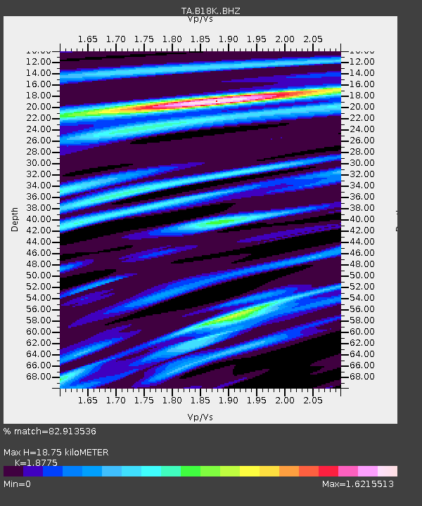
| Estimated Moho Depth: |
18.75 km |
| Estimated Crust Vp/Vs: |
1.88 |
| Assumed Crust Vp: |
5.906 km/s |
| Estimated Crust Vs: |
3.146 km/s |
| Estimated Crust Poisson's Ratio: |
0.30 |
|
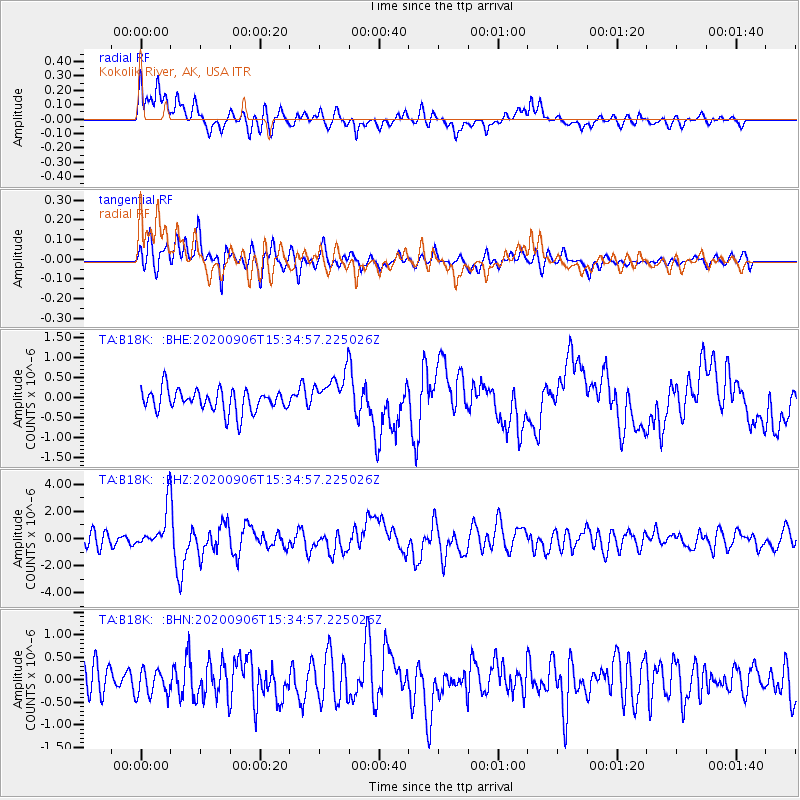
| Radial Match: |
82.913536 % |
| Radial Bump: |
400 |
| Transverse Match: |
75.15395 % |
| Transverse Bump: |
400 |
| SOD ConfigId: |
22732711 |
| Insert Time: |
2020-09-20 15:34:43.160 +0000 |
| GWidth: |
2.5 |
| Max Bumps: |
400 |
| Tol: |
0.001 |
|
Signal To Noise
| Channel | StoN | STA | LTA |
| TA:B18K: :BHZ:20200906T15:34:57.225026Z | 3.3567805 | 1.4572664E-6 | 4.341262E-7 |
| TA:B18K: :BHN:20200906T15:34:57.225026Z | 1.207086 | 2.9022155E-7 | 2.4043155E-7 |
| TA:B18K: :BHE:20200906T15:34:57.225026Z | 1.8212887 | 5.0266584E-7 | 2.7599458E-7 |
| Arrivals |
| Ps | 2.9 SECOND |
| PpPs | 8.9 SECOND |
| PsPs/PpSs | 12 SECOND |


