You are here: Home > Network List > TA - USArray Transportable Network (new EarthScope stations) Stations List
> Station D19K Kuna River, AK, USA > Earthquake Result Viewer
D19K Kuna River, AK, USA - Earthquake Result Viewer
| Earthquake location: |
Mindanao, Philippines |
| Earthquake latitude/longitude: |
6.3/125.8 |
| Earthquake time(UTC): |
2020/09/06 (250) 15:23:43 GMT |
| Earthquake Depth: |
120 km |
| Earthquake Magnitude: |
6.3 mww |
| Earthquake Catalog/Contributor: |
NEIC PDE/us |
|
| Network: |
TA USArray Transportable Network (new EarthScope stations) |
| Station: |
D19K Kuna River, AK, USA |
| Lat/Lon: |
68.49 N/158.12 W |
| Elevation: |
671 m |
|
| Distance: |
79.1 deg |
| Az: |
21.373 deg |
| Baz: |
259.279 deg |
| Ray Param: |
0.048919834 |
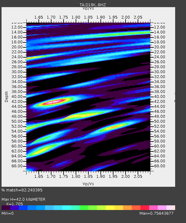
| Estimated Moho Depth: |
42.0 km |
| Estimated Crust Vp/Vs: |
1.71 |
| Assumed Crust Vp: |
6.221 km/s |
| Estimated Crust Vs: |
3.649 km/s |
| Estimated Crust Poisson's Ratio: |
0.24 |
|
| Radial Match: |
82.240395 % |
| Radial Bump: |
400 |
| Transverse Match: |
81.59058 % |
| Transverse Bump: |
400 |
| SOD ConfigId: |
22732711 |
| Insert Time: |
2020-09-20 15:34:59.781 +0000 |
| GWidth: |
2.5 |
| Max Bumps: |
400 |
| Tol: |
0.001 |
|

Signal To Noise
| Channel | StoN | STA | LTA |
| TA:D19K: :BHZ:20200906T15:35:03.299978Z | 14.006129 | 1.6357652E-6 | 1.16789245E-7 |
| TA:D19K: :BHN:20200906T15:35:03.299978Z | 1.1302985 | 9.5172126E-8 | 8.420087E-8 |
| TA:D19K: :BHE:20200906T15:35:03.299978Z | 4.248298 | 5.637527E-7 | 1.3270083E-7 |
| Arrivals |
| Ps | 4.9 SECOND |
| PpPs | 18 SECOND |
| PsPs/PpSs | 23 SECOND |


