You are here: Home > Network List > TA - USArray Transportable Network (new EarthScope stations) Stations List
> Station D23K Nanushuk River, AK USA > Earthquake Result Viewer
D23K Nanushuk River, AK USA - Earthquake Result Viewer
| Earthquake location: |
Mindanao, Philippines |
| Earthquake latitude/longitude: |
6.3/125.8 |
| Earthquake time(UTC): |
2020/09/06 (250) 15:23:43 GMT |
| Earthquake Depth: |
120 km |
| Earthquake Magnitude: |
6.3 mww |
| Earthquake Catalog/Contributor: |
NEIC PDE/us |
|
| Network: |
TA USArray Transportable Network (new EarthScope stations) |
| Station: |
D23K Nanushuk River, AK USA |
| Lat/Lon: |
68.97 N/150.68 W |
| Elevation: |
406 m |
|
| Distance: |
81.8 deg |
| Az: |
21.246 deg |
| Baz: |
266.181 deg |
| Ray Param: |
0.047031615 |
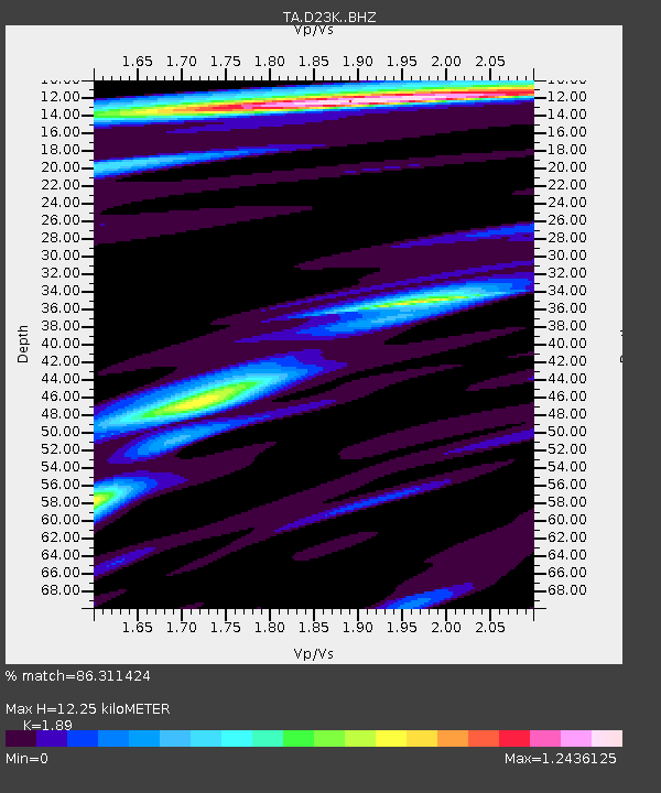
| Estimated Moho Depth: |
12.25 km |
| Estimated Crust Vp/Vs: |
1.89 |
| Assumed Crust Vp: |
6.221 km/s |
| Estimated Crust Vs: |
3.292 km/s |
| Estimated Crust Poisson's Ratio: |
0.31 |
|
| Radial Match: |
86.311424 % |
| Radial Bump: |
400 |
| Transverse Match: |
82.01865 % |
| Transverse Bump: |
400 |
| SOD ConfigId: |
22732711 |
| Insert Time: |
2020-09-20 15:35:04.906 +0000 |
| GWidth: |
2.5 |
| Max Bumps: |
400 |
| Tol: |
0.001 |
|
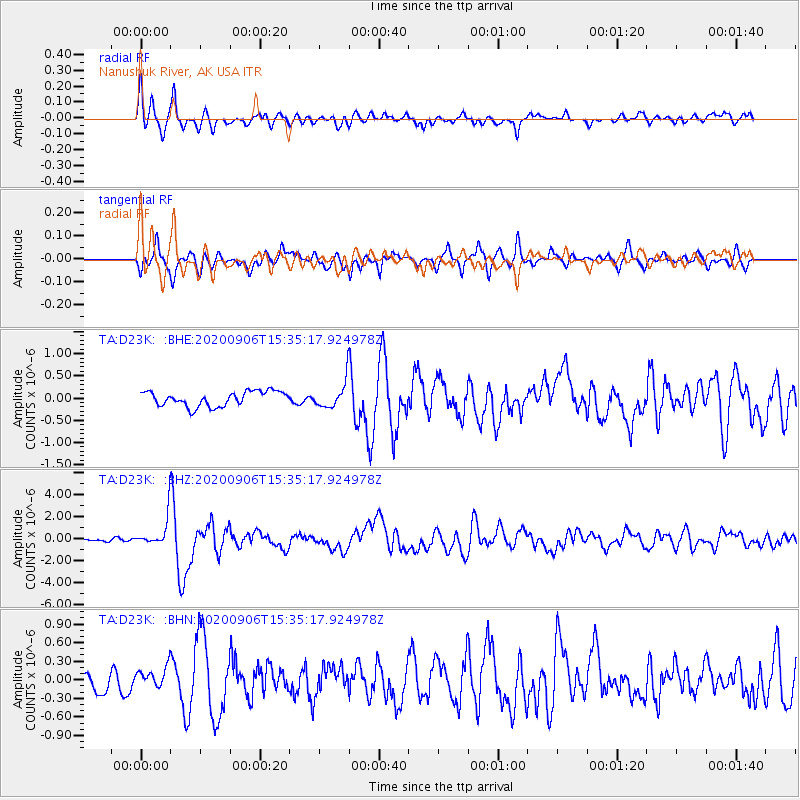
Signal To Noise
| Channel | StoN | STA | LTA |
| TA:D23K: :BHZ:20200906T15:35:17.924978Z | 9.187622 | 1.2941427E-6 | 1.4085721E-7 |
| TA:D23K: :BHN:20200906T15:35:17.924978Z | 1.0628804 | 1.6018821E-7 | 1.5071141E-7 |
| TA:D23K: :BHE:20200906T15:35:17.924978Z | 1.7517334 | 2.923582E-7 | 1.6689653E-7 |
| Arrivals |
| Ps | 1.8 SECOND |
| PpPs | 5.6 SECOND |
| PsPs/PpSs | 7.4 SECOND |


