You are here: Home > Network List > TA - USArray Transportable Network (new EarthScope stations) Stations List
> Station D27M Malcolm River, YT, CAN > Earthquake Result Viewer
D27M Malcolm River, YT, CAN - Earthquake Result Viewer
| Earthquake location: |
Mindanao, Philippines |
| Earthquake latitude/longitude: |
6.3/125.8 |
| Earthquake time(UTC): |
2020/09/06 (250) 15:23:43 GMT |
| Earthquake Depth: |
120 km |
| Earthquake Magnitude: |
6.3 mww |
| Earthquake Catalog/Contributor: |
NEIC PDE/us |
|
| Network: |
TA USArray Transportable Network (new EarthScope stations) |
| Station: |
D27M Malcolm River, YT, CAN |
| Lat/Lon: |
69.24 N/140.96 W |
| Elevation: |
896 m |
|
| Distance: |
85.3 deg |
| Az: |
20.924 deg |
| Baz: |
275.217 deg |
| Ray Param: |
0.044584673 |
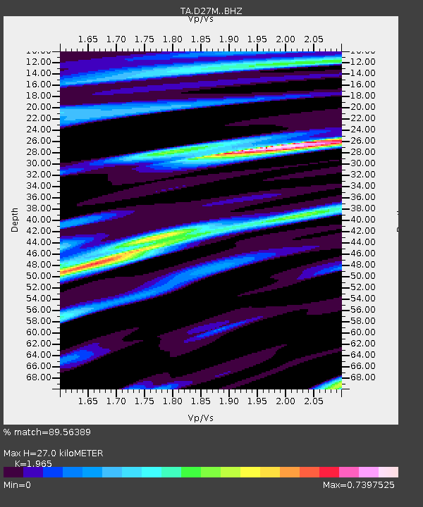
| Estimated Moho Depth: |
27.0 km |
| Estimated Crust Vp/Vs: |
1.97 |
| Assumed Crust Vp: |
6.522 km/s |
| Estimated Crust Vs: |
3.319 km/s |
| Estimated Crust Poisson's Ratio: |
0.33 |
|
| Radial Match: |
89.56389 % |
| Radial Bump: |
400 |
| Transverse Match: |
87.81074 % |
| Transverse Bump: |
400 |
| SOD ConfigId: |
22732711 |
| Insert Time: |
2020-09-20 15:35:08.188 +0000 |
| GWidth: |
2.5 |
| Max Bumps: |
400 |
| Tol: |
0.001 |
|

Signal To Noise
| Channel | StoN | STA | LTA |
| TA:D27M: :BHZ:20200906T15:35:35.600026Z | 12.68402 | 1.2214404E-6 | 9.629758E-8 |
| TA:D27M: :BHN:20200906T15:35:35.600026Z | 3.731115 | 1.7308841E-7 | 4.6390532E-8 |
| TA:D27M: :BHE:20200906T15:35:35.600026Z | 6.487735 | 2.9405763E-7 | 4.532516E-8 |
| Arrivals |
| Ps | 4.1 SECOND |
| PpPs | 12 SECOND |
| PsPs/PpSs | 16 SECOND |


