You are here: Home > Network List > UW - Pacific Northwest Regional Seismic Network Stations List
> Station BERY Pilchuck Tree Farm, Arlington, WA, USA > Earthquake Result Viewer
BERY Pilchuck Tree Farm, Arlington, WA, USA - Earthquake Result Viewer
| Earthquake location: |
Vanuatu Islands |
| Earthquake latitude/longitude: |
-17.1/168.5 |
| Earthquake time(UTC): |
2020/09/07 (251) 06:12:40 GMT |
| Earthquake Depth: |
10 km |
| Earthquake Magnitude: |
6.0 Mww |
| Earthquake Catalog/Contributor: |
NEIC PDE/us |
|
| Network: |
UW Pacific Northwest Regional Seismic Network |
| Station: |
BERY Pilchuck Tree Farm, Arlington, WA, USA |
| Lat/Lon: |
48.26 N/122.10 W |
| Elevation: |
150 m |
|
| Distance: |
89.6 deg |
| Az: |
38.726 deg |
| Baz: |
243.564 deg |
| Ray Param: |
0.04174387 |
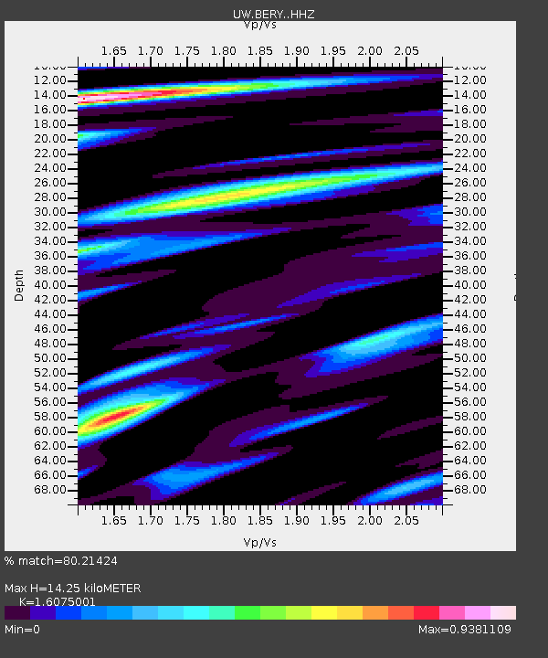
| Estimated Moho Depth: |
14.25 km |
| Estimated Crust Vp/Vs: |
1.61 |
| Assumed Crust Vp: |
6.566 km/s |
| Estimated Crust Vs: |
4.085 km/s |
| Estimated Crust Poisson's Ratio: |
0.18 |
|
| Radial Match: |
80.21424 % |
| Radial Bump: |
397 |
| Transverse Match: |
83.73871 % |
| Transverse Bump: |
308 |
| SOD ConfigId: |
22732711 |
| Insert Time: |
2020-09-21 06:27:48.137 +0000 |
| GWidth: |
2.5 |
| Max Bumps: |
400 |
| Tol: |
0.001 |
|

Signal To Noise
| Channel | StoN | STA | LTA |
| UW:BERY: :HHZ:20200907T06:25:06.189985Z | 7.0625277 | 3.9382093E-7 | 5.5762037E-8 |
| UW:BERY: :HHN:20200907T06:25:06.189985Z | 1.0198861 | 6.532245E-8 | 6.404877E-8 |
| UW:BERY: :HHE:20200907T06:25:06.189985Z | 1.5855969 | 1.1673579E-7 | 7.3622616E-8 |
| Arrivals |
| Ps | 1.4 SECOND |
| PpPs | 5.5 SECOND |
| PsPs/PpSs | 6.9 SECOND |


