You are here: Home > Network List > US - United States National Seismic Network Stations List
> Station CBKS Cedar Bluff, Kansas, USA > Earthquake Result Viewer
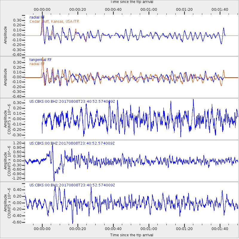
CBKS Cedar Bluff, Kansas, USA - Earthquake Result Viewer
*The percent match for this event was below the threshold and hence no stack was calculated.
| Earthquake location: |
Northern Xinjiang, China |
| Earthquake latitude/longitude: |
44.3/82.8 |
| Earthquake time(UTC): |
2017/08/08 (220) 23:27:53 GMT |
| Earthquake Depth: |
20 km |
| Earthquake Magnitude: |
6.3 Mww |
| Earthquake Catalog/Contributor: |
NEIC PDE/us |
|
| Network: |
US United States National Seismic Network |
| Station: |
CBKS Cedar Bluff, Kansas, USA |
| Lat/Lon: |
38.81 N/99.74 W |
| Elevation: |
677 m |
|
| Distance: |
97.2 deg |
| Az: |
2.026 deg |
| Baz: |
358.138 deg |
| Ray Param: |
$rayparam |
*The percent match for this event was below the threshold and hence was not used in the summary stack. |
|
| Radial Match: |
63.881363 % |
| Radial Bump: |
400 |
| Transverse Match: |
66.42102 % |
| Transverse Bump: |
400 |
| SOD ConfigId: |
2140511 |
| Insert Time: |
2017-08-22 15:22:39.232 +0000 |
| GWidth: |
2.5 |
| Max Bumps: |
400 |
| Tol: |
0.001 |
|
Signal To Noise
| Channel | StoN | STA | LTA |
| US:CBKS:00:BHZ:20170808T23:40:52.574009Z | 4.6093774 | 2.9621884E-7 | 6.42644E-8 |
| US:CBKS:00:BH1:20170808T23:40:52.574009Z | 1.2167927 | 1.4851774E-7 | 1.2205673E-7 |
| US:CBKS:00:BH2:20170808T23:40:52.574009Z | 0.72864425 | 7.9798376E-8 | 1.09516236E-7 |
| Arrivals |
| Ps | |
| PpPs | |
| PsPs/PpSs | |


