You are here: Home > Network List > TA - USArray Transportable Network (new EarthScope stations) Stations List
> Station R33M Jennings River, BC, CAN > Earthquake Result Viewer
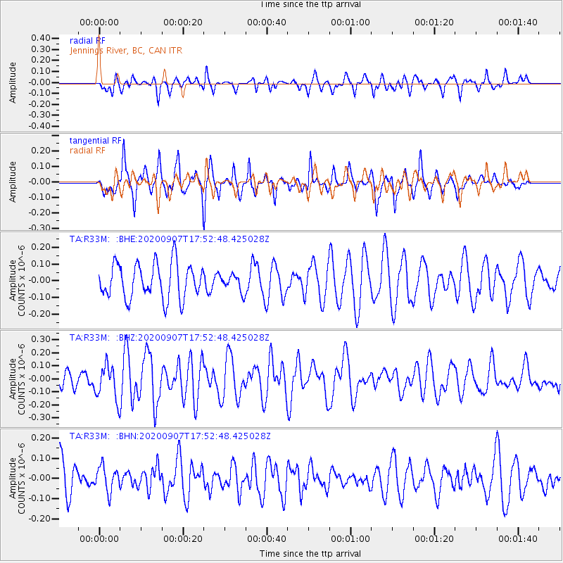
R33M Jennings River, BC, CAN - Earthquake Result Viewer
*The percent match for this event was below the threshold and hence no stack was calculated.
| Earthquake location: |
Easter Island Region |
| Earthquake latitude/longitude: |
-24.5/-112.0 |
| Earthquake time(UTC): |
2020/09/07 (251) 17:40:44 GMT |
| Earthquake Depth: |
10 km |
| Earthquake Magnitude: |
5.6 Mww |
| Earthquake Catalog/Contributor: |
NEIC PDE/us |
|
| Network: |
TA USArray Transportable Network (new EarthScope stations) |
| Station: |
R33M Jennings River, BC, CAN |
| Lat/Lon: |
59.39 N/130.97 W |
| Elevation: |
1437 m |
|
| Distance: |
85.1 deg |
| Az: |
350.386 deg |
| Baz: |
162.702 deg |
| Ray Param: |
$rayparam |
*The percent match for this event was below the threshold and hence was not used in the summary stack. |
|
| Radial Match: |
56.85382 % |
| Radial Bump: |
400 |
| Transverse Match: |
57.476315 % |
| Transverse Bump: |
343 |
| SOD ConfigId: |
22732711 |
| Insert Time: |
2020-09-21 17:56:42.678 +0000 |
| GWidth: |
2.5 |
| Max Bumps: |
400 |
| Tol: |
0.001 |
|
Signal To Noise
| Channel | StoN | STA | LTA |
| TA:R33M: :BHZ:20200907T17:52:48.425028Z | 2.7100027 | 1.3287836E-7 | 4.9032554E-8 |
| TA:R33M: :BHN:20200907T17:52:48.425028Z | 0.84705967 | 6.225371E-8 | 7.349389E-8 |
| TA:R33M: :BHE:20200907T17:52:48.425028Z | 0.4836288 | 5.1104426E-8 | 1.056687E-7 |
| Arrivals |
| Ps | |
| PpPs | |
| PsPs/PpSs | |


