You are here: Home > Network List > AV - Alaska Volcano Observatory Stations List
> Station MAPS Pakushin Southeast, Makushin Volcano, Alaska > Earthquake Result Viewer
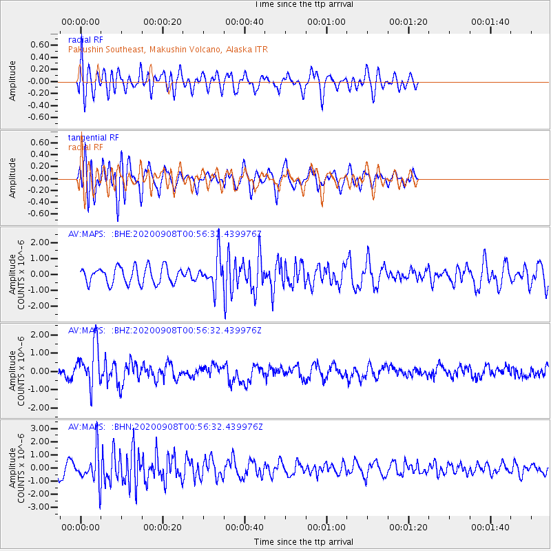
MAPS Pakushin Southeast, Makushin Volcano, Alaska - Earthquake Result Viewer
*The percent match for this event was below the threshold and hence no stack was calculated.
| Earthquake location: |
Banda Sea |
| Earthquake latitude/longitude: |
-4.9/129.8 |
| Earthquake time(UTC): |
2020/09/08 (252) 00:45:20 GMT |
| Earthquake Depth: |
174 km |
| Earthquake Magnitude: |
5.9 mww |
| Earthquake Catalog/Contributor: |
NEIC PDE/us |
|
| Network: |
AV Alaska Volcano Observatory |
| Station: |
MAPS Pakushin Southeast, Makushin Volcano, Alaska |
| Lat/Lon: |
53.81 N/166.94 W |
| Elevation: |
333 m |
|
| Distance: |
78.6 deg |
| Az: |
32.712 deg |
| Baz: |
245.218 deg |
| Ray Param: |
$rayparam |
*The percent match for this event was below the threshold and hence was not used in the summary stack. |
|
| Radial Match: |
50.8593 % |
| Radial Bump: |
400 |
| Transverse Match: |
59.54827 % |
| Transverse Bump: |
400 |
| SOD ConfigId: |
22732711 |
| Insert Time: |
2020-09-22 00:50:52.102 +0000 |
| GWidth: |
2.5 |
| Max Bumps: |
400 |
| Tol: |
0.001 |
|
Signal To Noise
| Channel | StoN | STA | LTA |
| AV:MAPS: :BHZ:20200908T00:56:32.439976Z | 2.6863658 | 1.169572E-6 | 4.3537332E-7 |
| AV:MAPS: :BHN:20200908T00:56:32.439976Z | 1.7495434 | 1.1984564E-6 | 6.85011E-7 |
| AV:MAPS: :BHE:20200908T00:56:32.439976Z | 2.0098722 | 1.0394186E-6 | 5.171566E-7 |
| Arrivals |
| Ps | |
| PpPs | |
| PsPs/PpSs | |


