You are here: Home > Network List > TA - USArray Transportable Network (new EarthScope stations) Stations List
> Station G21K Allakaket, AK, USA > Earthquake Result Viewer
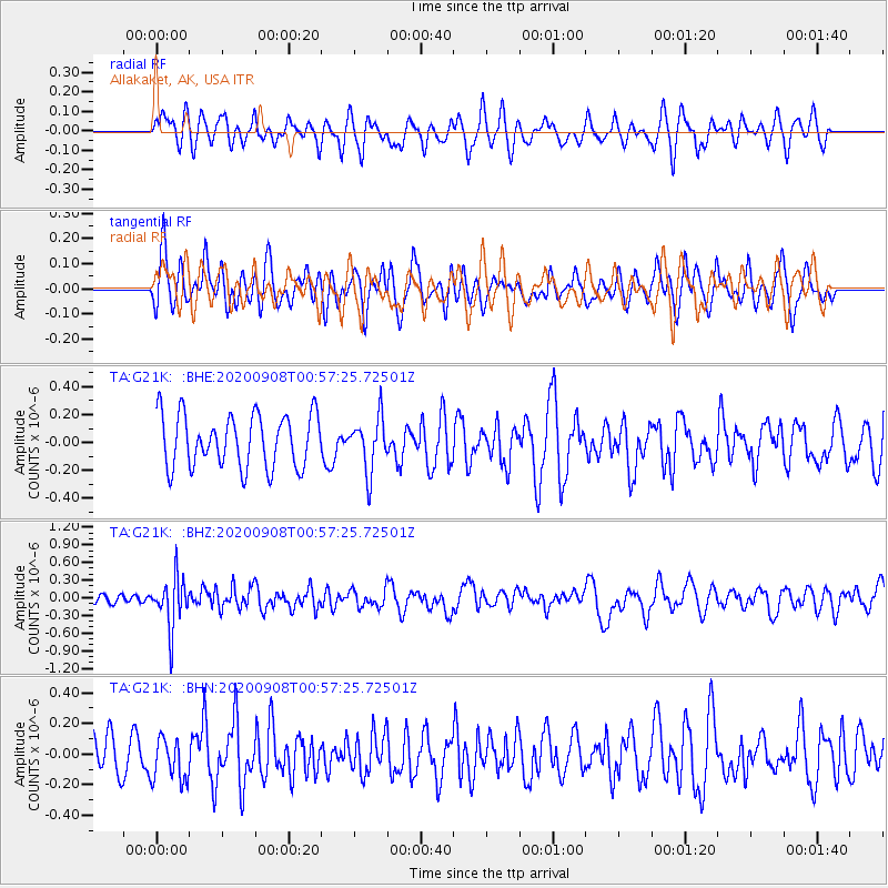
G21K Allakaket, AK, USA - Earthquake Result Viewer
*The percent match for this event was below the threshold and hence no stack was calculated.
| Earthquake location: |
Banda Sea |
| Earthquake latitude/longitude: |
-4.9/129.8 |
| Earthquake time(UTC): |
2020/09/08 (252) 00:45:20 GMT |
| Earthquake Depth: |
174 km |
| Earthquake Magnitude: |
5.9 mww |
| Earthquake Catalog/Contributor: |
NEIC PDE/us |
|
| Network: |
TA USArray Transportable Network (new EarthScope stations) |
| Station: |
G21K Allakaket, AK, USA |
| Lat/Lon: |
66.52 N/153.51 W |
| Elevation: |
446 m |
|
| Distance: |
89.2 deg |
| Az: |
22.96 deg |
| Baz: |
255.899 deg |
| Ray Param: |
$rayparam |
*The percent match for this event was below the threshold and hence was not used in the summary stack. |
|
| Radial Match: |
50.602093 % |
| Radial Bump: |
389 |
| Transverse Match: |
53.06442 % |
| Transverse Bump: |
400 |
| SOD ConfigId: |
22732711 |
| Insert Time: |
2020-09-22 00:56:31.153 +0000 |
| GWidth: |
2.5 |
| Max Bumps: |
400 |
| Tol: |
0.001 |
|
Signal To Noise
| Channel | StoN | STA | LTA |
| TA:G21K: :BHZ:20200908T00:57:25.72501Z | 4.1451035 | 4.332952E-7 | 1.0453182E-7 |
| TA:G21K: :BHN:20200908T00:57:25.72501Z | 0.9202887 | 1.4549417E-7 | 1.5809624E-7 |
| TA:G21K: :BHE:20200908T00:57:25.72501Z | 1.003927 | 1.8960885E-7 | 1.8886718E-7 |
| Arrivals |
| Ps | |
| PpPs | |
| PsPs/PpSs | |


