You are here: Home > Network List > TA - USArray Transportable Network (new EarthScope stations) Stations List
> Station A22K Sinclair Lake, AK, USA > Earthquake Result Viewer
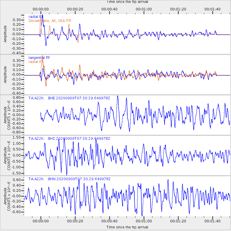
A22K Sinclair Lake, AK, USA - Earthquake Result Viewer
| Earthquake location: |
Talaud Islands, Indonesia |
| Earthquake latitude/longitude: |
4.2/126.6 |
| Earthquake time(UTC): |
2020/09/09 (253) 07:18:40 GMT |
| Earthquake Depth: |
18 km |
| Earthquake Magnitude: |
5.8 mww |
| Earthquake Catalog/Contributor: |
NEIC PDE/us |
|
| Network: |
TA USArray Transportable Network (new EarthScope stations) |
| Station: |
A22K Sinclair Lake, AK, USA |
| Lat/Lon: |
71.00 N/154.97 W |
| Elevation: |
6.0 m |
|
| Distance: |
82.3 deg |
| Az: |
18.888 deg |
| Baz: |
260.365 deg |
| Ray Param: |
0.046996675 |
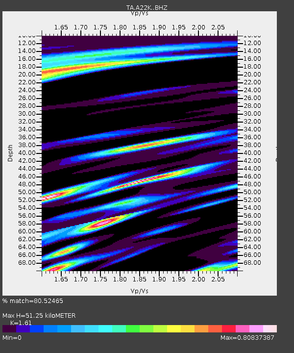
| Estimated Moho Depth: |
51.25 km |
| Estimated Crust Vp/Vs: |
1.61 |
| Assumed Crust Vp: |
5.782 km/s |
| Estimated Crust Vs: |
3.592 km/s |
| Estimated Crust Poisson's Ratio: |
0.19 |
|
| Radial Match: |
80.52465 % |
| Radial Bump: |
400 |
| Transverse Match: |
68.74228 % |
| Transverse Bump: |
400 |
| SOD ConfigId: |
22732711 |
| Insert Time: |
2020-09-23 07:27:00.385 +0000 |
| GWidth: |
2.5 |
| Max Bumps: |
400 |
| Tol: |
0.001 |
|
Signal To Noise
| Channel | StoN | STA | LTA |
| TA:A22K: :BHZ:20200909T07:30:29.649978Z | 2.7071643 | 5.428581E-7 | 2.0052649E-7 |
| TA:A22K: :BHN:20200909T07:30:29.649978Z | 1.1737151 | 2.1241179E-7 | 1.809739E-7 |
| TA:A22K: :BHE:20200909T07:30:29.649978Z | 1.5461134 | 2.5665443E-7 | 1.6599975E-7 |
| Arrivals |
| Ps | 5.5 SECOND |
| PpPs | 23 SECOND |
| PsPs/PpSs | 28 SECOND |


