You are here: Home > Network List > TA - USArray Transportable Network (new EarthScope stations) Stations List
> Station C19K Lookout Ridge, AK, USA > Earthquake Result Viewer
C19K Lookout Ridge, AK, USA - Earthquake Result Viewer
| Earthquake location: |
Talaud Islands, Indonesia |
| Earthquake latitude/longitude: |
4.2/126.6 |
| Earthquake time(UTC): |
2020/09/09 (253) 07:18:40 GMT |
| Earthquake Depth: |
18 km |
| Earthquake Magnitude: |
5.8 mww |
| Earthquake Catalog/Contributor: |
NEIC PDE/us |
|
| Network: |
TA USArray Transportable Network (new EarthScope stations) |
| Station: |
C19K Lookout Ridge, AK, USA |
| Lat/Lon: |
69.10 N/159.59 W |
| Elevation: |
745 m |
|
| Distance: |
80.3 deg |
| Az: |
20.452 deg |
| Baz: |
256.268 deg |
| Ray Param: |
0.048340805 |
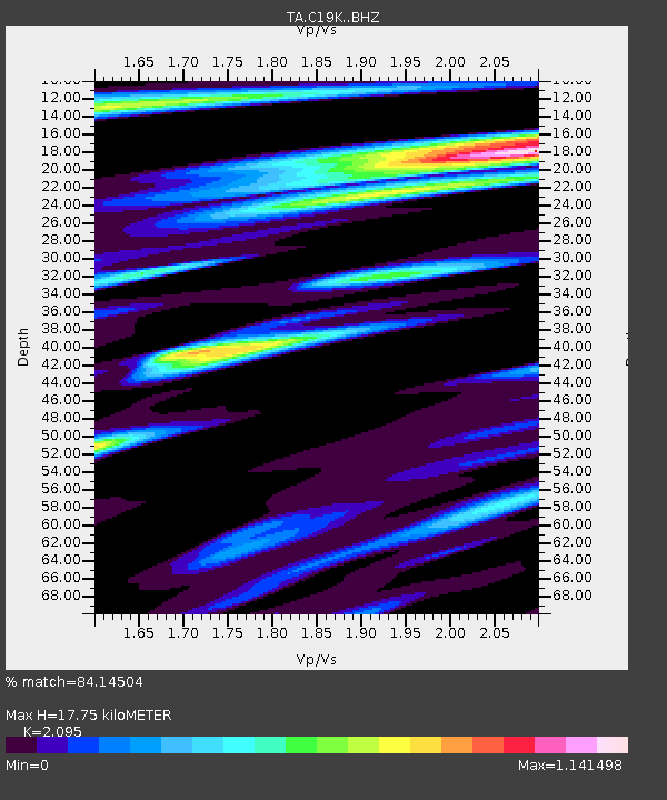
| Estimated Moho Depth: |
17.75 km |
| Estimated Crust Vp/Vs: |
2.10 |
| Assumed Crust Vp: |
6.221 km/s |
| Estimated Crust Vs: |
2.969 km/s |
| Estimated Crust Poisson's Ratio: |
0.35 |
|
| Radial Match: |
84.14504 % |
| Radial Bump: |
400 |
| Transverse Match: |
67.94986 % |
| Transverse Bump: |
400 |
| SOD ConfigId: |
22732711 |
| Insert Time: |
2020-09-23 07:27:08.152 +0000 |
| GWidth: |
2.5 |
| Max Bumps: |
400 |
| Tol: |
0.001 |
|

Signal To Noise
| Channel | StoN | STA | LTA |
| TA:C19K: :BHZ:20200909T07:30:19.425002Z | 3.4403765 | 3.8120476E-7 | 1.1080321E-7 |
| TA:C19K: :BHN:20200909T07:30:19.425002Z | 1.102162 | 1.02818035E-7 | 9.328759E-8 |
| TA:C19K: :BHE:20200909T07:30:19.425002Z | 1.0596372 | 9.0110085E-8 | 8.503862E-8 |
| Arrivals |
| Ps | 3.2 SECOND |
| PpPs | 8.6 SECOND |
| PsPs/PpSs | 12 SECOND |


