You are here: Home > Network List > GS - US Geological Survey Networks Stations List
> Station MT01 Lincoln Ranger Stn, Helena Natl Forest, Montana, USA > Earthquake Result Viewer
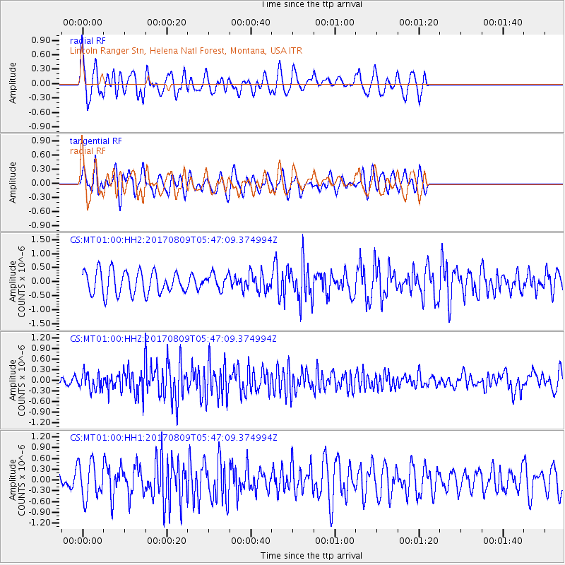
MT01 Lincoln Ranger Stn, Helena Natl Forest, Montana, USA - Earthquake Result Viewer
*The percent match for this event was below the threshold and hence no stack was calculated.
| Earthquake location: |
Fox Islands, Aleutian Islands |
| Earthquake latitude/longitude: |
52.6/-169.2 |
| Earthquake time(UTC): |
2017/08/09 (221) 05:40:42 GMT |
| Earthquake Depth: |
47 km |
| Earthquake Magnitude: |
5.3 mb |
| Earthquake Catalog/Contributor: |
NEIC PDE/us |
|
| Network: |
GS US Geological Survey Networks |
| Station: |
MT01 Lincoln Ranger Stn, Helena Natl Forest, Montana, USA |
| Lat/Lon: |
46.95 N/112.66 W |
| Elevation: |
1318 m |
|
| Distance: |
36.1 deg |
| Az: |
75.72 deg |
| Baz: |
300.286 deg |
| Ray Param: |
$rayparam |
*The percent match for this event was below the threshold and hence was not used in the summary stack. |
|
| Radial Match: |
66.415565 % |
| Radial Bump: |
400 |
| Transverse Match: |
58.54249 % |
| Transverse Bump: |
400 |
| SOD ConfigId: |
2140511 |
| Insert Time: |
2017-08-22 21:40:19.382 +0000 |
| GWidth: |
2.5 |
| Max Bumps: |
400 |
| Tol: |
0.001 |
|
Signal To Noise
| Channel | StoN | STA | LTA |
| GS:MT01:00:HHZ:20170809T05:47:09.374994Z | 2.734718 | 2.3902018E-7 | 8.7402135E-8 |
| GS:MT01:00:HH1:20170809T05:47:09.374994Z | 1.7901173 | 4.955926E-7 | 2.7684922E-7 |
| GS:MT01:00:HH2:20170809T05:47:09.374994Z | 0.68265 | 2.7790085E-7 | 4.0709125E-7 |
| Arrivals |
| Ps | |
| PpPs | |
| PsPs/PpSs | |


