You are here: Home > Network List > TA - USArray Transportable Network (new EarthScope stations) Stations List
> Station E20K Nigu River, AK, USA > Earthquake Result Viewer
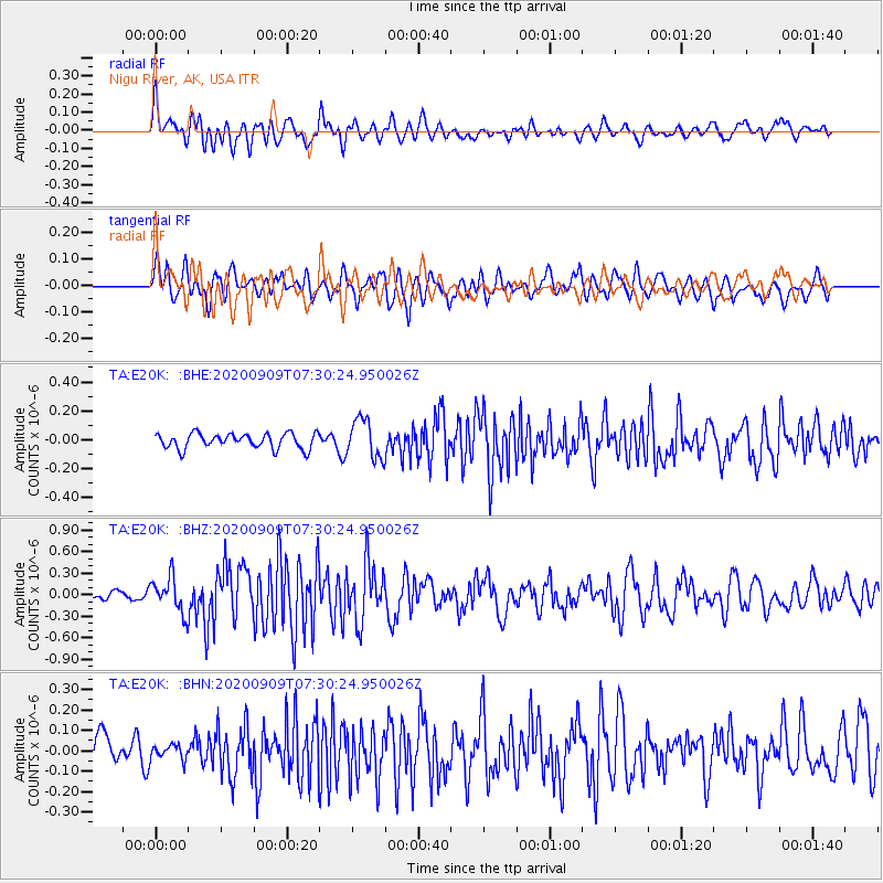
E20K Nigu River, AK, USA - Earthquake Result Viewer
*The percent match for this event was below the threshold and hence no stack was calculated.
| Earthquake location: |
Talaud Islands, Indonesia |
| Earthquake latitude/longitude: |
4.2/126.6 |
| Earthquake time(UTC): |
2020/09/09 (253) 07:18:40 GMT |
| Earthquake Depth: |
18 km |
| Earthquake Magnitude: |
5.8 mww |
| Earthquake Catalog/Contributor: |
NEIC PDE/us |
|
| Network: |
TA USArray Transportable Network (new EarthScope stations) |
| Station: |
E20K Nigu River, AK, USA |
| Lat/Lon: |
68.26 N/156.19 W |
| Elevation: |
866 m |
|
| Distance: |
81.4 deg |
| Az: |
21.559 deg |
| Baz: |
259.608 deg |
| Ray Param: |
$rayparam |
*The percent match for this event was below the threshold and hence was not used in the summary stack. |
|
| Radial Match: |
66.53204 % |
| Radial Bump: |
400 |
| Transverse Match: |
65.56205 % |
| Transverse Bump: |
400 |
| SOD ConfigId: |
22732711 |
| Insert Time: |
2020-09-23 07:27:30.756 +0000 |
| GWidth: |
2.5 |
| Max Bumps: |
400 |
| Tol: |
0.001 |
|
Signal To Noise
| Channel | StoN | STA | LTA |
| TA:E20K: :BHZ:20200909T07:30:24.950026Z | 3.5782447 | 2.4829816E-7 | 6.939106E-8 |
| TA:E20K: :BHN:20200909T07:30:24.950026Z | 0.50025296 | 3.5613176E-8 | 7.1190335E-8 |
| TA:E20K: :BHE:20200909T07:30:24.950026Z | 2.6080697 | 1.3486837E-7 | 5.171195E-8 |
| Arrivals |
| Ps | |
| PpPs | |
| PsPs/PpSs | |


