You are here: Home > Network List > TA - USArray Transportable Network (new EarthScope stations) Stations List
> Station F21K Alatna River, AK, USA > Earthquake Result Viewer
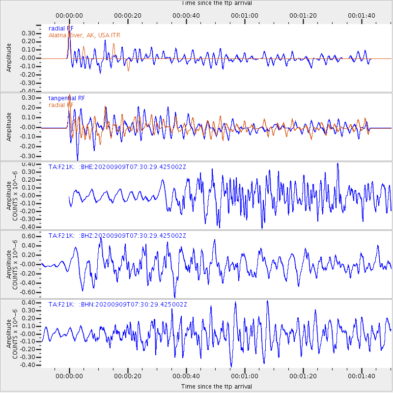
F21K Alatna River, AK, USA - Earthquake Result Viewer
*The percent match for this event was below the threshold and hence no stack was calculated.
| Earthquake location: |
Talaud Islands, Indonesia |
| Earthquake latitude/longitude: |
4.2/126.6 |
| Earthquake time(UTC): |
2020/09/09 (253) 07:18:40 GMT |
| Earthquake Depth: |
18 km |
| Earthquake Magnitude: |
5.8 mww |
| Earthquake Catalog/Contributor: |
NEIC PDE/us |
|
| Network: |
TA USArray Transportable Network (new EarthScope stations) |
| Station: |
F21K Alatna River, AK, USA |
| Lat/Lon: |
67.22 N/153.48 W |
| Elevation: |
597 m |
|
| Distance: |
82.2 deg |
| Az: |
22.76 deg |
| Baz: |
262.281 deg |
| Ray Param: |
$rayparam |
*The percent match for this event was below the threshold and hence was not used in the summary stack. |
|
| Radial Match: |
69.56753 % |
| Radial Bump: |
400 |
| Transverse Match: |
67.44105 % |
| Transverse Bump: |
400 |
| SOD ConfigId: |
22732711 |
| Insert Time: |
2020-09-23 07:27:50.103 +0000 |
| GWidth: |
2.5 |
| Max Bumps: |
400 |
| Tol: |
0.001 |
|
Signal To Noise
| Channel | StoN | STA | LTA |
| TA:F21K: :BHZ:20200909T07:30:29.425002Z | 4.9305496 | 2.7812035E-7 | 5.6407575E-8 |
| TA:F21K: :BHN:20200909T07:30:29.425002Z | 0.9764092 | 6.117642E-8 | 6.2654486E-8 |
| TA:F21K: :BHE:20200909T07:30:29.425002Z | 2.4178066 | 1.2694653E-7 | 5.2504834E-8 |
| Arrivals |
| Ps | |
| PpPs | |
| PsPs/PpSs | |


