You are here: Home > Network List > AE - Arizona Broadband Seismic Network Stations List
> Station TONTO Roosevelt/Tonto Basin > Earthquake Result Viewer
TONTO Roosevelt/Tonto Basin - Earthquake Result Viewer
| Earthquake location: |
Northern Chile |
| Earthquake latitude/longitude: |
-21.4/-69.9 |
| Earthquake time(UTC): |
2020/09/11 (255) 07:35:57 GMT |
| Earthquake Depth: |
51 km |
| Earthquake Magnitude: |
6.3 Mww |
| Earthquake Catalog/Contributor: |
NEIC PDE/us |
|
| Network: |
AE Arizona Broadband Seismic Network |
| Station: |
TONTO Roosevelt/Tonto Basin |
| Lat/Lon: |
33.65 N/111.01 W |
| Elevation: |
661 m |
|
| Distance: |
67.3 deg |
| Az: |
323.523 deg |
| Baz: |
138.381 deg |
| Ray Param: |
0.056944795 |
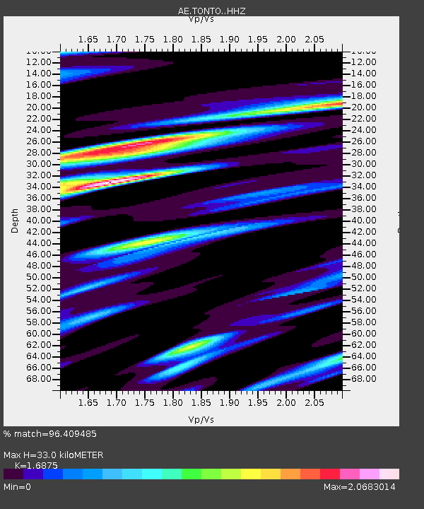
| Estimated Moho Depth: |
33.0 km |
| Estimated Crust Vp/Vs: |
1.69 |
| Assumed Crust Vp: |
6.276 km/s |
| Estimated Crust Vs: |
3.719 km/s |
| Estimated Crust Poisson's Ratio: |
0.23 |
|
| Radial Match: |
96.409485 % |
| Radial Bump: |
400 |
| Transverse Match: |
84.614555 % |
| Transverse Bump: |
400 |
| SOD ConfigId: |
22732711 |
| Insert Time: |
2020-09-25 07:38:05.874 +0000 |
| GWidth: |
2.5 |
| Max Bumps: |
400 |
| Tol: |
0.001 |
|

Signal To Noise
| Channel | StoN | STA | LTA |
| AE:TONTO: :HHZ:20200911T07:46:16.618976Z | 28.83632 | 1.9009349E-6 | 6.592155E-8 |
| AE:TONTO: :HHN:20200911T07:46:16.618976Z | 11.798806 | 1.2463204E-6 | 1.0563105E-7 |
| AE:TONTO: :HHE:20200911T07:46:16.618976Z | 12.602573 | 9.1134496E-7 | 7.2314194E-8 |
| Arrivals |
| Ps | 3.8 SECOND |
| PpPs | 14 SECOND |
| PsPs/PpSs | 17 SECOND |


