You are here: Home > Network List > CC - Cascade Chain Volcano Monitoring Stations List
> Station PALM Top of Palmer Lift > Earthquake Result Viewer
PALM Top of Palmer Lift - Earthquake Result Viewer
| Earthquake location: |
Northern Chile |
| Earthquake latitude/longitude: |
-21.4/-69.9 |
| Earthquake time(UTC): |
2020/09/11 (255) 07:35:57 GMT |
| Earthquake Depth: |
51 km |
| Earthquake Magnitude: |
6.3 Mww |
| Earthquake Catalog/Contributor: |
NEIC PDE/us |
|
| Network: |
CC Cascade Chain Volcano Monitoring |
| Station: |
PALM Top of Palmer Lift |
| Lat/Lon: |
45.36 N/121.71 W |
| Elevation: |
2590 m |
|
| Distance: |
81.4 deg |
| Az: |
325.915 deg |
| Baz: |
132.204 deg |
| Ray Param: |
0.047508992 |
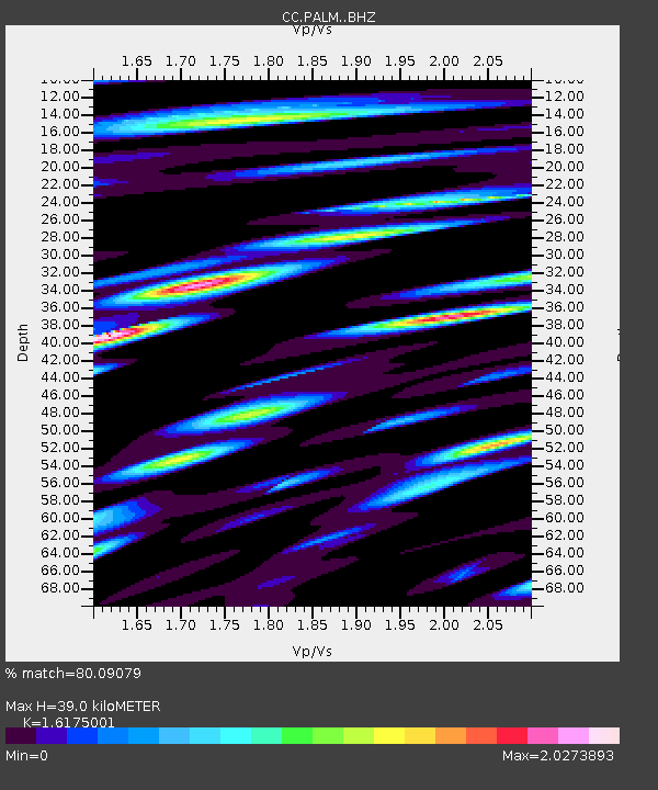
| Estimated Moho Depth: |
39.0 km |
| Estimated Crust Vp/Vs: |
1.62 |
| Assumed Crust Vp: |
6.597 km/s |
| Estimated Crust Vs: |
4.079 km/s |
| Estimated Crust Poisson's Ratio: |
0.19 |
|
| Radial Match: |
80.09079 % |
| Radial Bump: |
400 |
| Transverse Match: |
70.0034 % |
| Transverse Bump: |
400 |
| SOD ConfigId: |
22732711 |
| Insert Time: |
2020-09-25 07:41:08.849 +0000 |
| GWidth: |
2.5 |
| Max Bumps: |
400 |
| Tol: |
0.001 |
|

Signal To Noise
| Channel | StoN | STA | LTA |
| CC:PALM: :BHZ:20200911T07:47:38.360003Z | 11.803662 | 1.4482018E-6 | 1.2269089E-7 |
| CC:PALM: :BHN:20200911T07:47:38.360003Z | 1.8770885 | 5.0268244E-7 | 2.67799E-7 |
| CC:PALM: :BHE:20200911T07:47:38.360003Z | 5.8530636 | 9.2233165E-7 | 1.57581E-7 |
| Arrivals |
| Ps | 3.8 SECOND |
| PpPs | 15 SECOND |
| PsPs/PpSs | 19 SECOND |


