You are here: Home > Network List > IW - Intermountain West Stations List
> Station MOOW Moose Ponds, Wyoming, USA > Earthquake Result Viewer
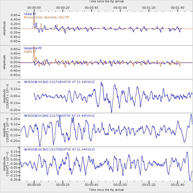
MOOW Moose Ponds, Wyoming, USA - Earthquake Result Viewer
*The percent match for this event was below the threshold and hence no stack was calculated.
| Earthquake location: |
Fox Islands, Aleutian Islands |
| Earthquake latitude/longitude: |
52.6/-169.2 |
| Earthquake time(UTC): |
2017/08/09 (221) 05:40:42 GMT |
| Earthquake Depth: |
47 km |
| Earthquake Magnitude: |
5.3 mb |
| Earthquake Catalog/Contributor: |
NEIC PDE/us |
|
| Network: |
IW Intermountain West |
| Station: |
MOOW Moose Ponds, Wyoming, USA |
| Lat/Lon: |
43.75 N/110.74 W |
| Elevation: |
2128 m |
|
| Distance: |
39.0 deg |
| Az: |
78.985 deg |
| Baz: |
304.231 deg |
| Ray Param: |
$rayparam |
*The percent match for this event was below the threshold and hence was not used in the summary stack. |
|
| Radial Match: |
75.612785 % |
| Radial Bump: |
302 |
| Transverse Match: |
56.84211 % |
| Transverse Bump: |
400 |
| SOD ConfigId: |
2140511 |
| Insert Time: |
2017-08-22 21:41:20.981 +0000 |
| GWidth: |
2.5 |
| Max Bumps: |
400 |
| Tol: |
0.001 |
|
Signal To Noise
| Channel | StoN | STA | LTA |
| IW:MOOW:00:BHZ:20170809T05:47:33.445001Z | 3.0722215 | 1.3382103E-7 | 4.3558394E-8 |
| IW:MOOW:00:BH1:20170809T05:47:33.445001Z | 1.297162 | 6.166731E-8 | 4.7540173E-8 |
| IW:MOOW:00:BH2:20170809T05:47:33.445001Z | 1.0968816 | 2.9784518E-8 | 2.7153813E-8 |
| Arrivals |
| Ps | |
| PpPs | |
| PsPs/PpSs | |


