You are here: Home > Network List > MB - Montana Regional Seismic Network Stations List
> Station GBMT Granite Butte > Earthquake Result Viewer
GBMT Granite Butte - Earthquake Result Viewer
| Earthquake location: |
Northern Chile |
| Earthquake latitude/longitude: |
-21.4/-69.9 |
| Earthquake time(UTC): |
2020/09/11 (255) 07:35:57 GMT |
| Earthquake Depth: |
51 km |
| Earthquake Magnitude: |
6.3 Mww |
| Earthquake Catalog/Contributor: |
NEIC PDE/us |
|
| Network: |
MB Montana Regional Seismic Network |
| Station: |
GBMT Granite Butte |
| Lat/Lon: |
46.86 N/112.46 W |
| Elevation: |
2248 m |
|
| Distance: |
78.0 deg |
| Az: |
331.675 deg |
| Baz: |
139.883 deg |
| Ray Param: |
0.04982897 |
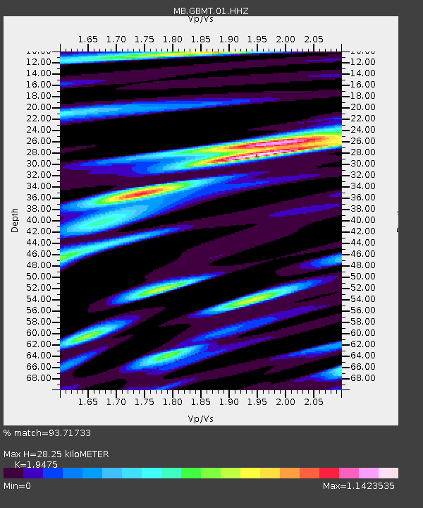
| Estimated Moho Depth: |
28.25 km |
| Estimated Crust Vp/Vs: |
1.95 |
| Assumed Crust Vp: |
6.353 km/s |
| Estimated Crust Vs: |
3.262 km/s |
| Estimated Crust Poisson's Ratio: |
0.32 |
|
| Radial Match: |
93.71733 % |
| Radial Bump: |
375 |
| Transverse Match: |
80.360344 % |
| Transverse Bump: |
400 |
| SOD ConfigId: |
22732711 |
| Insert Time: |
2020-09-25 07:50:11.801 +0000 |
| GWidth: |
2.5 |
| Max Bumps: |
400 |
| Tol: |
0.001 |
|

Signal To Noise
| Channel | StoN | STA | LTA |
| MB:GBMT:01:HHZ:20200911T07:47:20.070025Z | 15.274839 | 6.092551E-7 | 3.988619E-8 |
| MB:GBMT:01:HHN:20200911T07:47:20.070025Z | 3.543596 | 1.2732731E-7 | 3.5931667E-8 |
| MB:GBMT:01:HHE:20200911T07:47:20.070025Z | 2.8974843 | 1.4675695E-7 | 5.0649778E-8 |
| Arrivals |
| Ps | 4.3 SECOND |
| PpPs | 13 SECOND |
| PsPs/PpSs | 17 SECOND |


