You are here: Home > Network List > N4 - Central and EAstern US Network Stations List
> Station I49A Point Hope, MI, USA > Earthquake Result Viewer
I49A Point Hope, MI, USA - Earthquake Result Viewer
| Earthquake location: |
Northern Chile |
| Earthquake latitude/longitude: |
-21.4/-69.9 |
| Earthquake time(UTC): |
2020/09/11 (255) 07:35:57 GMT |
| Earthquake Depth: |
51 km |
| Earthquake Magnitude: |
6.3 Mww |
| Earthquake Catalog/Contributor: |
NEIC PDE/us |
|
| Network: |
N4 Central and EAstern US Network |
| Station: |
I49A Point Hope, MI, USA |
| Lat/Lon: |
43.94 N/82.82 W |
| Elevation: |
217 m |
|
| Distance: |
66.1 deg |
| Az: |
349.815 deg |
| Baz: |
166.814 deg |
| Ray Param: |
0.057744343 |
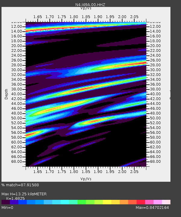
| Estimated Moho Depth: |
13.25 km |
| Estimated Crust Vp/Vs: |
1.68 |
| Assumed Crust Vp: |
6.483 km/s |
| Estimated Crust Vs: |
3.853 km/s |
| Estimated Crust Poisson's Ratio: |
0.23 |
|
| Radial Match: |
87.91588 % |
| Radial Bump: |
400 |
| Transverse Match: |
78.101944 % |
| Transverse Bump: |
400 |
| SOD ConfigId: |
22732711 |
| Insert Time: |
2020-09-25 07:51:17.454 +0000 |
| GWidth: |
2.5 |
| Max Bumps: |
400 |
| Tol: |
0.001 |
|

Signal To Noise
| Channel | StoN | STA | LTA |
| N4:I49A:00:HHZ:20200911T07:46:08.800006Z | 3.3783953 | 6.7793076E-7 | 2.0066649E-7 |
| N4:I49A:00:HH1:20200911T07:46:08.800006Z | 2.3089116 | 4.0304764E-7 | 1.7456175E-7 |
| N4:I49A:00:HH2:20200911T07:46:08.800006Z | 1.2801108 | 1.7484074E-7 | 1.365825E-7 |
| Arrivals |
| Ps | 1.5 SECOND |
| PpPs | 5.2 SECOND |
| PsPs/PpSs | 6.7 SECOND |


