You are here: Home > Network List > N4 - Central and EAstern US Network Stations List
> Station I62A Tamworth, NH, USA > Earthquake Result Viewer
I62A Tamworth, NH, USA - Earthquake Result Viewer
| Earthquake location: |
Northern Chile |
| Earthquake latitude/longitude: |
-21.4/-69.9 |
| Earthquake time(UTC): |
2020/09/11 (255) 07:35:57 GMT |
| Earthquake Depth: |
51 km |
| Earthquake Magnitude: |
6.3 Mww |
| Earthquake Catalog/Contributor: |
NEIC PDE/us |
|
| Network: |
N4 Central and EAstern US Network |
| Station: |
I62A Tamworth, NH, USA |
| Lat/Lon: |
43.87 N/71.34 W |
| Elevation: |
264 m |
|
| Distance: |
65.0 deg |
| Az: |
358.849 deg |
| Baz: |
178.517 deg |
| Ray Param: |
0.05848281 |
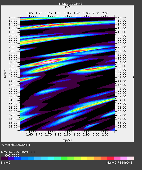
| Estimated Moho Depth: |
33.5 km |
| Estimated Crust Vp/Vs: |
1.75 |
| Assumed Crust Vp: |
6.419 km/s |
| Estimated Crust Vs: |
3.663 km/s |
| Estimated Crust Poisson's Ratio: |
0.26 |
|
| Radial Match: |
96.32381 % |
| Radial Bump: |
400 |
| Transverse Match: |
82.789474 % |
| Transverse Bump: |
400 |
| SOD ConfigId: |
22732711 |
| Insert Time: |
2020-09-25 07:51:18.786 +0000 |
| GWidth: |
2.5 |
| Max Bumps: |
400 |
| Tol: |
0.001 |
|

Signal To Noise
| Channel | StoN | STA | LTA |
| N4:I62A:00:HHZ:20200911T07:46:01.549029Z | 3.4010382 | 7.354434E-7 | 2.1624085E-7 |
| N4:I62A:00:HH1:20200911T07:46:01.549029Z | 2.7128468 | 3.998245E-7 | 1.4738188E-7 |
| N4:I62A:00:HH2:20200911T07:46:01.549029Z | 1.543245 | 2.1410116E-7 | 1.387344E-7 |
| Arrivals |
| Ps | 4.1 SECOND |
| PpPs | 14 SECOND |
| PsPs/PpSs | 18 SECOND |


