You are here: Home > Network List > N4 - Central and EAstern US Network Stations List
> Station N47A Urbana, IN, USA > Earthquake Result Viewer
N47A Urbana, IN, USA - Earthquake Result Viewer
| Earthquake location: |
Northern Chile |
| Earthquake latitude/longitude: |
-21.4/-69.9 |
| Earthquake time(UTC): |
2020/09/11 (255) 07:35:57 GMT |
| Earthquake Depth: |
51 km |
| Earthquake Magnitude: |
6.3 Mww |
| Earthquake Catalog/Contributor: |
NEIC PDE/us |
|
| Network: |
N4 Central and EAstern US Network |
| Station: |
N47A Urbana, IN, USA |
| Lat/Lon: |
40.88 N/85.69 W |
| Elevation: |
252 m |
|
| Distance: |
63.7 deg |
| Az: |
346.682 deg |
| Baz: |
163.554 deg |
| Ray Param: |
0.059317917 |
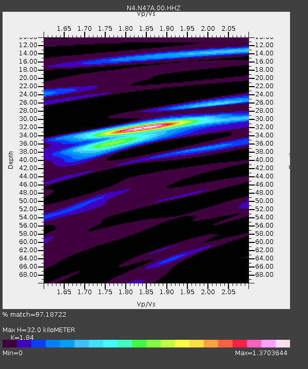
| Estimated Moho Depth: |
32.0 km |
| Estimated Crust Vp/Vs: |
1.84 |
| Assumed Crust Vp: |
6.498 km/s |
| Estimated Crust Vs: |
3.531 km/s |
| Estimated Crust Poisson's Ratio: |
0.29 |
|
| Radial Match: |
97.18722 % |
| Radial Bump: |
244 |
| Transverse Match: |
89.346886 % |
| Transverse Bump: |
379 |
| SOD ConfigId: |
22732711 |
| Insert Time: |
2020-09-25 07:52:00.330 +0000 |
| GWidth: |
2.5 |
| Max Bumps: |
400 |
| Tol: |
0.001 |
|

Signal To Noise
| Channel | StoN | STA | LTA |
| N4:N47A:00:HHZ:20200911T07:45:53.159991Z | 7.0613537 | 8.3027055E-7 | 1.17579525E-7 |
| N4:N47A:00:HH1:20200911T07:45:53.159991Z | 4.1639166 | 3.2993148E-7 | 7.923585E-8 |
| N4:N47A:00:HH2:20200911T07:45:53.159991Z | 1.1910133 | 1.2883737E-7 | 1.0817459E-7 |
| Arrivals |
| Ps | 4.3 SECOND |
| PpPs | 13 SECOND |
| PsPs/PpSs | 18 SECOND |


