You are here: Home > Network List > N4 - Central and EAstern US Network Stations List
> Station R55A Marlinton, WV, USA > Earthquake Result Viewer
R55A Marlinton, WV, USA - Earthquake Result Viewer
| Earthquake location: |
Northern Chile |
| Earthquake latitude/longitude: |
-21.4/-69.9 |
| Earthquake time(UTC): |
2020/09/11 (255) 07:35:57 GMT |
| Earthquake Depth: |
51 km |
| Earthquake Magnitude: |
6.3 Mww |
| Earthquake Catalog/Contributor: |
NEIC PDE/us |
|
| Network: |
N4 Central and EAstern US Network |
| Station: |
R55A Marlinton, WV, USA |
| Lat/Lon: |
38.28 N/80.12 W |
| Elevation: |
833 m |
|
| Distance: |
60.1 deg |
| Az: |
350.729 deg |
| Baz: |
169.002 deg |
| Ray Param: |
0.061625738 |
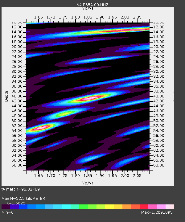
| Estimated Moho Depth: |
52.5 km |
| Estimated Crust Vp/Vs: |
1.66 |
| Assumed Crust Vp: |
6.207 km/s |
| Estimated Crust Vs: |
3.734 km/s |
| Estimated Crust Poisson's Ratio: |
0.22 |
|
| Radial Match: |
96.02789 % |
| Radial Bump: |
400 |
| Transverse Match: |
92.82649 % |
| Transverse Bump: |
400 |
| SOD ConfigId: |
22732711 |
| Insert Time: |
2020-09-25 07:52:41.403 +0000 |
| GWidth: |
2.5 |
| Max Bumps: |
400 |
| Tol: |
0.001 |
|

Signal To Noise
| Channel | StoN | STA | LTA |
| N4:R55A:00:HHZ:20200911T07:45:29.428973Z | 5.974089 | 1.2668772E-6 | 2.1206198E-7 |
| N4:R55A:00:HH1:20200911T07:45:29.428973Z | 5.5271115 | 5.8050233E-7 | 1.0502815E-7 |
| N4:R55A:00:HH2:20200911T07:45:29.428973Z | 1.1394128 | 1.3599139E-7 | 1.1935217E-7 |
| Arrivals |
| Ps | 5.9 SECOND |
| PpPs | 21 SECOND |
| PsPs/PpSs | 27 SECOND |


