You are here: Home > Network List > XC95 - Southern Alps Passive Seismic Experiment Stations List
> Station CLAA Clarks Junction > Earthquake Result Viewer
CLAA Clarks Junction - Earthquake Result Viewer

| Earthquake location: |
Irian Jaya, Indonesia |
| Earthquake latitude/longitude: |
-3.7/140.3 |
| Earthquake time(UTC): |
1995/12/19 (353) 23:28:12 GMT |
| Earthquake Depth: |
71 km |
| Earthquake Magnitude: |
6.2 MB, 6.5 UNKNOWN |
| Earthquake Catalog/Contributor: |
WHDF/NEIC |
|
| Network: |
XC Southern Alps Passive Seismic Experiment |
| Station: |
CLAA Clarks Junction |
| Lat/Lon: |
45.79 S/170.04 E |
| Elevation: |
432 m |
|
| Distance: |
49.3 deg |
| Az: |
152.731 deg |
| Baz: |
319.196 deg |
| Ray Param: |
0.06856656 |
| Estimated Moho Depth: |
28.0 km |
| Estimated Crust Vp/Vs: |
1.62 |
| Assumed Crust Vp: |
6.461 km/s |
| Estimated Crust Vs: |
3.995 km/s |
| Estimated Crust Poisson's Ratio: |
0.19 |
|
| Radial Match: |
81.43765 % |
| Radial Bump: |
376 |
| Transverse Match: |
71.83349 % |
| Transverse Bump: |
400 |
| SOD ConfigId: |
4480 |
| Insert Time: |
2010-02-26 15:06:22.093 +0000 |
| GWidth: |
2.5 |
| Max Bumps: |
400 |
| Tol: |
0.001 |
|
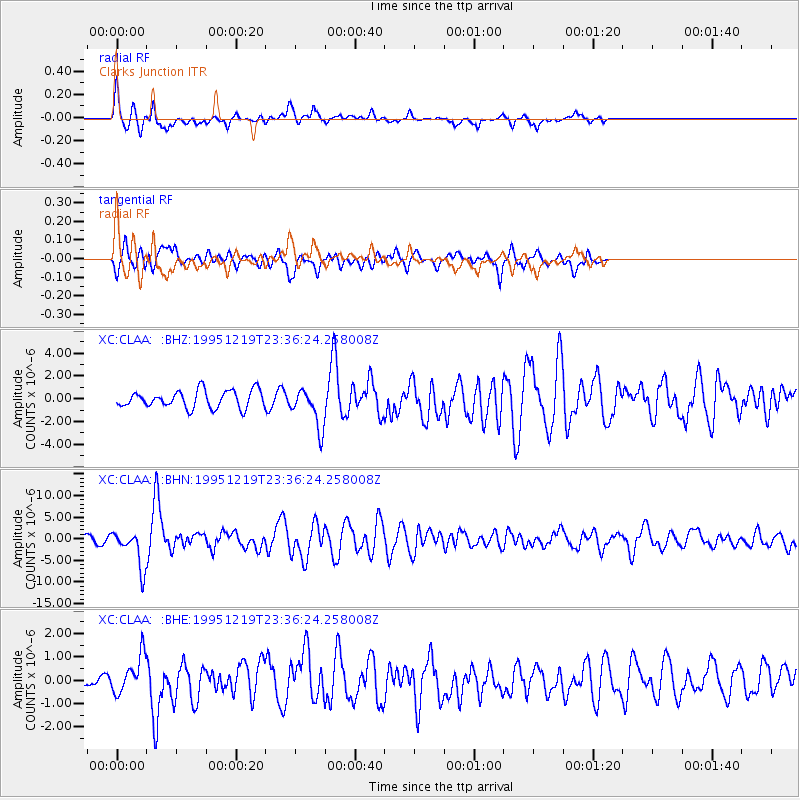
Signal To Noise
| Channel | StoN | STA | LTA |
| XC:CLAA: :BHN:19951219T23:36:24.258008Z | 2.942068 | 4.3318096E-6 | 1.472369E-6 |
| XC:CLAA: :BHE:19951219T23:36:24.258008Z | 1.9607649 | 7.954354E-7 | 4.056761E-7 |
| XC:CLAA: :BHZ:19951219T23:36:24.258008Z | 2.2685044 | 1.720085E-6 | 7.582463E-7 |
| Arrivals |
| Ps | 2.9 SECOND |
| PpPs | 11 SECOND |
| PsPs/PpSs | 13 SECOND |


